TÜRKİYE’S NEW CORRIDORS SERIES 06 | HALKALI–KAPIKULE HIGH-SPEED RAIL LINE: WHERE IS THE NEW FRONTIER OF REAL ESTATE, INDUSTRIAL AND LOGISTICS INVESTMENT IN THRACE?
Why Is the Halkalı–Kapıkule Line Strategic for Real Estate?
In the global economy, connectivity has become as decisive as production itself. Investment decisions are influenced not only by the country in which a factory is located, but also by how quickly it can reach a port, railway, motorway, and market. Europe’s efforts to diversify supply chains, the growing role of rail in low-carbon logistics, and the strengthening of alternative corridors in Asia–Europe trade require Türkiye’s road and rail gateways to Europe to be assessed from a new economic perspective.
The Halkalı–Kapıkule High-Speed Rail Line is one of the most strategic components of this broader picture in Türkiye. According to the Ministry of Transport and Infrastructure’s statement dated June 6, 2026, the system is approximately 229 kilometers long and is being developed as a double-track, electrified railway suitable for operating speeds of up to 200 kilometers per hour. Once the line is completed, the Halkalı–Kapıkule passenger journey is targeted to fall from approximately 4 hours to 1.5 hours, while freight transit time is targeted to decrease from 8.5 hours to 3.5 hours.
For investors, however, the more critical data point is not travel time alone. The Ministry expects annual passenger capacity to increase from 600,000 to approximately 3 million and annual freight capacity from 1.5 million tons to 9.5 million tons. This indicates that the project’s economic function extends well beyond passenger transport and aims to establish a higher-capacity transport backbone between Istanbul, Thrace, border logistics, and European markets.
For this reason, the key investment question is not “Where will the high-speed train stop?” but “At which locations are railway + motorway + organized industrial zone + freight station + warehouse + new factory + planning change + employment + access to Europe strengthening together?”
The Çerkezköy–Kapıkule Section Is Now Being Tested in the Field
The Halkalı–Kapıkule line is no longer discussed solely through project plans. A test run was carried out on the Çerkezköy–Kapıkule section on June 6, 2026. The Ministry stated that, following the tests and completion of certification processes, it aims to put this 153-kilometer section into operation before the end of 2026.
Shortly afterward, on June 17–18, 2026, two scheduled freight trains were operated in opposite directions on the new Çerkezköy–Kapıkule line. According to official records, this was a reciprocal, one-off operation conducted as part of testing, operational readiness, and acceptance procedures. The train departing from Çerkezköy reached Edirne with 18 wagons and approximately 1,310 tons of freight, while the train in the opposite direction completed its journey from Edirne to Çerkezköy.
It would therefore be incorrect to interpret this development as “regular commercial freight operations have begun.” However, testing the line’s geometric and operational conditions in the field with actual freight trains is important because it shows that the corridor has moved from project drawings into the operational-readiness phase.
The Halkalı–Kapıkule System Consists of Three Critical Sections
It is not sufficient to evaluate the corridor solely through the Çerkezköy–Kapıkule section. The current project structure should be read through three main segments:
- Halkalı–Ispartakule: approximately 7 kilometers connecting Istanbul.
- Ispartakule–Çerkezköy: approximately 69 kilometers forming the transition section.
- Çerkezköy–Kapıkule: approximately 153 kilometers forming the main Thrace section currently in testing and certification.
As of June 2026, the Ministry of Transport and Infrastructure states that construction work on the final approximately 7-kilometer section connecting Ispartakule to Halkalı is nearing completion and that this section is planned to open during 2026. Work on the Ispartakule–Çerkezköy section is continuing. Real estate analysis should therefore not assume that the entire corridor is at the same stage of timing or project maturity.
Halkalı–Ispartakule: The Threshold Where Istanbul’s Economy Opens toward Thrace
Istanbul lies at the beginning of the corridor; however, the critical area for real estate is not the city center but the metropolitan economy’s western frontier. Halkalı functions as a strong interchange through Marmaray and the national railway network, while Ispartakule lies on residential, transport, and commercial axes expanding westward from Istanbul.
Reading the high-speed rail effect here solely through price appreciation may be misleading. Because of proximity to Istanbul, land and housing values are already influenced by many variables. The more relevant issue is which new economic functions are supported by greater accessibility: commercial centers, logistics uses, labor access, new transport integrations, and planning decisions.
For Ispartakule, the investment question is not price; it is functional change.
Çatalca–Büyükçekmece Hinterland: Where Could Istanbul’s Industrial and Logistics Pressure Shift?
As the corridor moves from Ispartakule toward Thrace, the economic geography changes. Development on Istanbul’s western side is not limited to housing; industrial, logistics, warehousing, and large-scale commercial uses are also being assessed across a wider hinterland because of metropolitan land costs and operational requirements.
For this reason, looking only at station surroundings to assess the effect of the Halkalı–Kapıkule line within Istanbul could overlook a significant transformation. Rail capacity is not a directional force on its own; however, when combined with motorway access, logistics facilities, industrial areas, and planning decisions, it could strengthen the function of selected areas within the Istanbul–Thrace economic transition belt.
The northern and western hinterlands of Çatalca and Büyükçekmece should therefore be examined not under a simple “residential land” label, but as a transition zone between Istanbul’s metropolitan economy and Thrace’s industrial geography.
Çerkezköy–Kapaklı: One of the Corridor’s Strongest Industrial Nodes
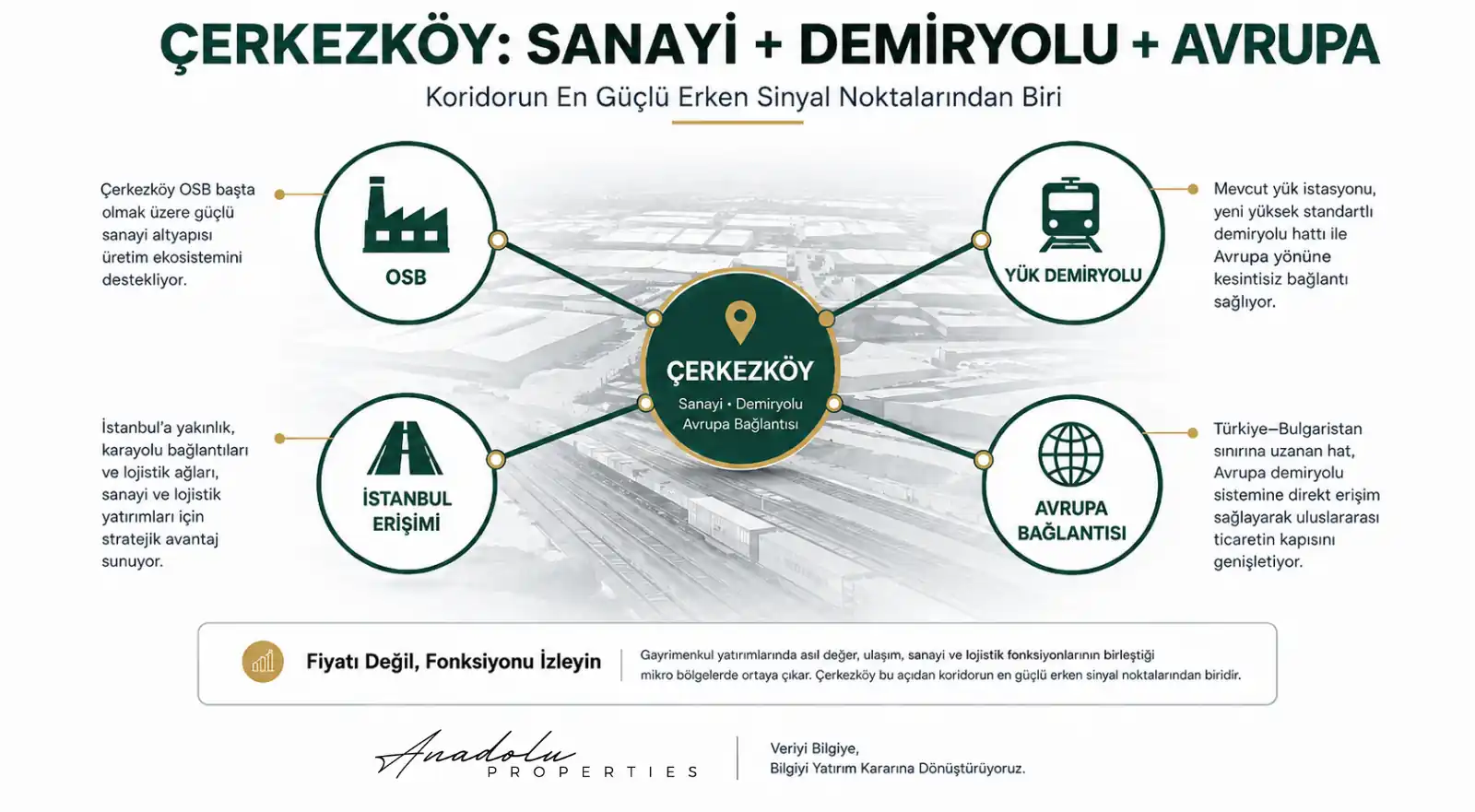
One of the most critical areas of the line for real estate and investment analysis is the Çerkezköy–Kapaklı area. The reason is that the high-speed railway is not entering an empty geography; it is connecting into an existing and powerful production ecosystem.
Industrial infrastructure in the region—particularly the Çerkezköy Organized Industrial Zone—together with proximity to Istanbul and road access toward Europe has long defined the area’s economic character. In 2025, the Ministry of Industry and Technology announced that the Çerkezköy OIZ Wastewater Recovery Facility project had been included in the investment program. The existing wastewater-treatment infrastructure of ÇOSB also demonstrates that the scale of production in the area should be evaluated not only by the number of plots, but together with infrastructure capacity.
The importance of the new rail connection becomes more tangible here. Çerkezköy is also an industrial node with rail access for freight transport. Four major layers therefore intersect in the same geography:
- a strong industrial base and organized industrial zone infrastructure,
- rail access and freight movement,
- relative proximity to the Istanbul market and labor force,
- rail connection to Europe through Kapıkule.
However, generalizations such as “every plot in Çerkezköy will appreciate” do not constitute investment analysis. OIZ expansion directions, access to freight stations and main roads, zoning function, the supply of industrial plots, warehouse use, environmental infrastructure, and workforce settlements should be assessed at the micro-location level.
In this corridor, the early signal may appear in demand for industrial and logistics real estate before it appears in residential prices.
Ergene–Velimeşe–Veliköy: A Production Belt Larger Than the Direct Station Effect
Examining only the points with stations would create a serious gap in Thrace’s economic map. A broad belt between Çerkezköy and Çorlu contains organized industrial zones and dense production clusters. The Thrace Development Agency’s 2024–2028 Regional Plan also treats the region’s organized industrial zones, logistics centers, ports, and railway links not as independent elements, but as components of a multimodal system.
For this reason, the key question in Ergene, Velimeşe, Veliköy, and their surroundings is not which parcel the train passes directly beside. The more meaningful question is how access from these production areas to Çerkezköy and other rail/freight connections will change.
Is the factory moving closer to the railway, or is the railway changing the factory’s logistics access?
If both processes strengthen simultaneously, a different value layer may emerge for industrial real estate, warehousing, and auxiliary production functions. Evidence of this should be sought first in investment decisions, permits, infrastructure investments, and logistics flows—not in asking prices.
Lüleburgaz: A Mid-Corridor Node Between Industry, Agriculture, and Rail
Moving west from Çerkezköy, Lüleburgaz presents a different economic profile. The Ministry of Transport and Infrastructure has stated that the new station infrastructure in Lüleburgaz is nearing completion as a modern, high-capacity facility.
From an investment perspective, however, the station building itself is not a sufficient indicator. Lüleburgaz’s industrial base, agricultural production, food-processing activities, storage requirements, and road connections should be assessed together with the new rail capacity.
The possibility that the area could strengthen its position in production, processing, and distribution between Çerkezköy and Edirne may be examined, but this possibility must be verified through new industrial investment, warehouse use, freight flows, and planning decisions.
Babaeski–Büyükkarıştıran: The Role of Smaller Centers in a Major Corridor
Transformation in corridor economies does not always begin in major cities. According to the Ministry’s June 2026 statement, Babaeski and Büyükkarıştıran are also among the locations where new station infrastructure is nearing completion.
Nevertheless, a station alone does not mean economic transformation. Existing industry, agricultural production, access to main roads, storage needs, commercial uses, and local planning decisions must be assessed together. Smaller settlements located between major production centers can gain auxiliary production, warehouse, or distribution functions when cost and logistics balances change.
Whether this scenario is actually materializing will be indicated—before listing prices—by permits, parcel functions, investment incentives, business openings, and transport connections.
Edirne: From Border City to Logistics and Service Node
Edirne’s role in the corridor should be read beyond history and tourism, through the border economy between Türkiye and Europe. During the one-off reciprocal freight-train operation in June 2026, the arrival in Edirne of the train departing from Çerkezköy became one tangible indication that the new line had been tested in the field for freight transport.
Investment analysis here should not be limited to housing demand. Customs, logistics services, warehousing, trade, accommodation, freight transfer, and service sectors linked to border crossings should be evaluated within a broader economic framework.
In Edirne’s real estate market, the first signs of a railway effect may appear in commercial real estate, warehousing, service space, and logistics-operational demand before they appear in residential prices.
Kapıkule: One of the Strongest Capacity Signals in Real Estate Analysis
Kapıkule is the point where the corridor’s economic logic is most visible. The main issue here is not the high-speed passenger station, but the capacity of the international rail border terminal.
According to the Ministry of Transport and Infrastructure’s statement dated June 6, 2026, the current Kapıkule station area of approximately 253,000 square meters is being expanded to 660,000 square meters, while the number of tracks within the station is increasing from 23 to 42. Through this expansion, the Ministry aims to increase train reception and shunting capacity, reduce train congestion, and accelerate customs and inspection procedures.
For a real estate investor, this data may be more meaningful than travel time. Physical terminal expansion is an infrastructure change that can directly affect the capacity of border logistics.
For this reason, around Edirne–Kapıkule, investors should monitor not only land prices but also warehousing investments, logistics facilities, customs services, truck–rail integration, commercial uses, accommodation, and planning decisions.
The European Connection: The Project’s TEN-T and Middle Corridor Dimension
Viewing the Halkalı–Kapıkule project solely as a transport investment in Thrace would narrow the broader picture. The Çerkezköy–Kapıkule section is being developed with joint financing under Türkiye–European Union financial cooperation. The Ministry of Transport and Infrastructure states that the project plays a strategic role in integrating Türkiye’s transport networks with the Trans-European Transport Network (TEN-T) to high standards. European Commission documents likewise describe the Halkalı–Kapıkule line as one of the backbone investments directly connecting Türkiye to the TEN-T railway network via Bulgaria.
This international connection does not imply a direct or automatic increase in real estate prices. However, if access from production centers to European markets, freight capacity, border operations, and multimodal logistics investment all strengthen simultaneously, Thrace’s economic function may change.
The central issue is the expansion of the physical capacity linking Türkiye to the European economic system.
Where Is the New Frontier of Real Estate?
It would not be appropriate to answer this question with the name of a single district. Different economic functions may emerge along the corridor, and the investment thesis for each area should be tested against a different set of data.
Halkalı–Ispartakule: The urban threshold where Istanbul’s metropolitan economy connects to the European rail corridor. Accessibility, new transport integrations, and commercial functions should be monitored here.
Çatalca hinterland: A transition area in which Istanbul’s land costs, logistics requirements, and westward economic expansion should be observed.
Çerkezköy–Kapaklı: A strong production node where industry, OIZ infrastructure, rail freight access, proximity to Istanbul, and the European connection intersect in the same economic geography.
Ergene–Velimeşe–Veliköy: A production belt that should be monitored less for direct station effects than for the wider industrial ecosystem’s access to new rail capacity.
Lüleburgaz: A mid-corridor center where industry, agriculture, storage, and rail access can be assessed together.
Babaeski–Büyükkarıştıran: Areas to monitor at the micro level for auxiliary production, warehousing, and distribution functions between larger centers.
Edirne: A regional center where border trade, the service sector, and rail logistics could develop together.
Kapıkule: The international logistics gateway through which Türkiye–Europe freight physically moves and where terminal capacity is being significantly expanded.
An Early-Warning System for Investors: A Function Map Before a Price Map
A high-speed rail line is not an investment thesis on its own. A more robust approach is to monitor whether economic functions are becoming concentrated at the same points.
- If there is only high-speed rail: a transport signal.
- If high-speed rail intersects with an organized industrial zone: a production signal.
- If a freight station or strong freight access is added: a logistics signal.
- If there is also a motorway connection: the accessibility signal strengthens.
- If new factories and warehouses arrive: capital movement may begin to materialize.
- If planning changes, employment, and new commercial uses accompany these developments: the potential for regional economic transformation deserves more serious investigation.
Investors should therefore examine a function map before a price map. Land prices can often price in development expectations in advance, whereas the sustainability of an investment is tested by use function, infrastructure capacity, planning decisions, and actual economic demand.
First Early Signal: Micro-Location Analysis in Çerkezköy
Çerkezköy should be treated as a separate category within this corridor. A strong industrial base, OIZ infrastructure, rail access, proximity to Istanbul, and a new high-standard line toward Europe all converge in the same geography.
The correct question, however, is not “Will Çerkezköy appreciate?” A more analytical question is:
In which micro-locations of Çerkezköy is the economic function strengthening?
Two parcels within the same district may have entirely different risk/return profiles because of zoning status, access to industrial areas, road frontage, infrastructure, environmental constraints, distance to the freight station, and planning decisions. Industrial plots, warehouse demand, OIZ infrastructure investment, labor movement, and new transport links should therefore be monitored together.
Second Early Signal: Expansion of Terminal Capacity at Kapıkule
While most attention is focused on high-speed rail stations, a more measurable real estate data point is emerging at Kapıkule: expansion of the station area from 253,000 square meters to 660,000 square meters and an increase in the number of tracks from 23 to 42.
This physical expansion is a direct infrastructure signal aimed at increasing the capacity of cross-border rail operations. If customs activity, warehousing investment, logistics-company movements, commercial facilities, transport links, and planning decisions around Kapıkule are monitored simultaneously, it may be possible to identify the expansion of the area’s logistics-service economy at an earlier stage.
Third Early Signal: Production and Logistics Pressure from Istanbul toward Thrace
One of the line’s least visible effects may come not from the railway itself, but from Istanbul. High land costs, density, transformation of industrial areas, and the large-space requirements of logistics operations may, over the long term, support the relocation of production and warehousing activities toward surrounding regions.
Thrace is already one of the important recipients of this movement. New rail capacity will not create the process on its own; however, when combined with European access, existing organized industrial zones, motorways, and large production areas, it may support the attractiveness of selected areas for industrial and logistics investment.
The “new frontier” of real estate may therefore emerge not where Istanbul’s provincial boundary ends, but where the influence of Istanbul’s metropolitan economy begins to generate new economic functions.
What Changes for Investors Looking from Europe toward Türkiye?
For Turkish investors living in Europe and international investors researching long-term real estate opportunities in Türkiye, the significance of the Halkalı–Kapıkule line is not limited to easier transport. The corridor aims to connect Türkiye’s production areas and border logistics with the European railway network at higher capacity.
For remote investment decisions, large infrastructure projects of this kind can create a compelling narrative; however, the project announcement itself is not sufficient for an investment decision. The parcel’s zoning status, ownership record, planning scale, actual road access, infrastructure, genuine proximity to industrial/logistics functions, and comparable market data must also be verified.
In particular, listing phrases such as “the high-speed train passes nearby” or “close to the OIZ” are no substitute for parcel-level verification against official data. Whether a property can genuinely benefit from the corridor economy can only be understood through its use function and accessibility data.
Reading Thrace’s New Economic Frontier Through Data
For investors, the significance of the Halkalı–Kapıkule High-Speed Rail Line is broader than simply reaching Edirne from Istanbul more quickly. The central issue is the expansion of Türkiye’s rail capacity toward Europe and how industry, logistics, and border operations will connect with that new capacity.
In Çerkezköy, industry intersects with rail access. Thrace’s OIZ belt is being repositioned within a wider logistics network. Lüleburgaz and Babaeski are gaining access through new station infrastructure. Edirne may connect its border and service economy more closely with rail logistics. At Kapıkule, the physical capacity of the terminal is being significantly expanded.
None of these developments alone guarantees an increase in real estate values. In the coming years, OIZ expansions, new factory investments, warehouses and logistics facilities, freight-train movements, border-crossing volumes, motorway connections, zoning-plan changes, employment, and population movements should be monitored within the same dataset.
For investors, the right question is not “Which district does the high-speed rail line pass through?” but “In Thrace, positioned between Istanbul’s economic power and Europe’s trade network, at which new nodes are production, logistics, and capital beginning to concentrate?”
The answer may reveal not only the future of the Halkalı–Kapıkule line, but also the new economic frontiers of the real estate market extending from Istanbul to the European border. In Thrace, the first data point to reveal tomorrow’s investment map may not always be land prices; sometimes a more meaningful early signal is the point where production pressure flowing out of Istanbul begins to meet freight moving toward Europe.
Mustafa Yılmaz
CEO – Anadolu Properties
Europe – Türkiye Investment Bridge