TÜRKİYE’S NEW CORRIDORS SERIES 05 | BURSA HIGH-SPEED RAIL LINE AND THE NEW RAIL ECONOMY: WHERE COULD LAND AND LOGISTICS DEMAND SHIFT ALONG THE OSMANELİ–YENİŞEHİR–BURSA–BANDIRMA AXIS?
More Than a High-Speed Rail Line: Could Bursa’s Production and Logistics Map Change?
A high-speed rail line does more than shorten travel time between two cities. Within the right economic structure, it creates a new layer of accessibility that can influence industrial location decisions, the positioning of logistics centers, residential preferences of the workforce, warehousing areas, commercial corridors, and the use value of land.
For this reason, the Bandırma–Bursa–Yenişehir–Osmaneli High-Speed Rail Project should not be viewed solely as a passenger transport investment. According to the Ministry of Transport and Infrastructure’s statement dated 24 May 2026, the line is planned to be 201 kilometers long and designed for speeds of up to 250 kilometers per hour; once fully completed, it is expected to have capacity to serve approximately 30 million passengers and 59 million tons of freight annually. The 106-kilometer Osmaneli–Bursa section is targeted for completion in the second half of 2026, while the section extending westward from Bursa toward TEKNOSAB, Karacabey, Dağkadı and Kuşcenneti is targeted for completion in 2028. These are current project targets; the implementation schedule may change over time.
Source: Republic of Türkiye Ministry of Transport and Infrastructure – statement dated 24 May 2026
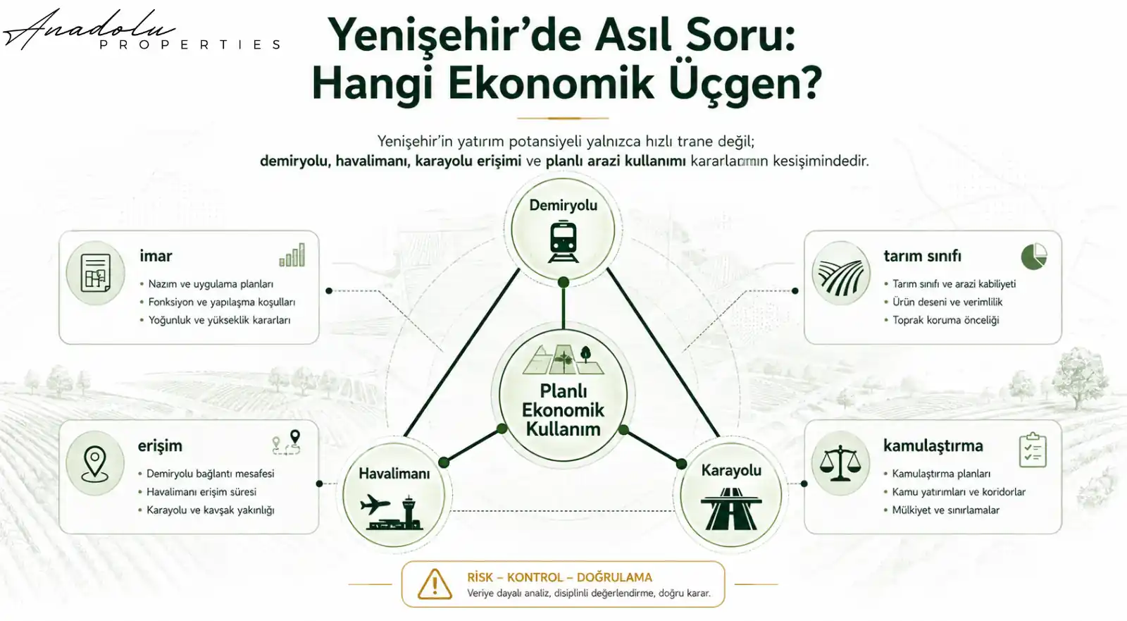
From a real estate perspective, the main question is not “Where will the train pass?” A more meaningful question is: in which micro-locations will rail, industry, ports, highways and planned urban growth begin to form the same economic system?
Because the real estate impact of major infrastructure investments often emerges not around a single station, but at points where different transport modes, production areas and planning decisions reinforce one another.
What Does the News Say, and What Does the Economy Tell Us?
One of the project’s most notable aspects is its freight transport capacity. The Ministry’s stated target of 59 million tons of annual capacity means the line should also be evaluated in terms of Bursa industry’s access to the Sea of Marmara, ports and Türkiye’s main railway network.
To the east, Osmaneli functions as a junction connecting Bursa to the Ankara–Istanbul high-speed rail network. Along the announced route, Osmaneli, Yenişehir, Yenişehir Airport, Gürsu and Bursa form the main points of the eastern section. To the west, the corridor extends from Bursa toward Bandırma via TEKNOSAB, Karacabey, Dağkadı and Kuşcenneti.
The project could therefore create a two-way economic movement: national rail access into Bursa from the east, and a new westward connection from Bursa along an industry–logistics–port axis. The broader picture can be read through the following chain: Ankara–Istanbul rail network → Osmaneli → Yenişehir → Bursa → TEKNOSAB → Karacabey → Bandırma → Sea of Marmara.
The Main Change for Bursa: Integrating Industry with Sea and Rail
Bursa has a strong production base in sectors such as textiles, automotive, machinery and metalworking, agro-industry, food and furniture. The Bursa Chamber of Commerce and Industry also identifies these sectors as prominent components of the city’s economic structure. For this reason, the line’s real estate impact should be assessed not only through new housing demand, but also through the spatial requirements of the production and logistics economy.
Source: Bursa Chamber of Commerce and Industry – Bursa Economy
As industry expands, it requires large and functional land, strong transport links and predictable logistics costs. While land supply and urban density are more constrained in central Bursa, the western corridor along TEKNOSAB–Karacabey–Bandırma offers a different scale. Adding rail to this axis could strengthen the possibility of a functional westward expansion of the existing industrial belt.
For this reason, it is not sufficient to interpret Bursa’s future growth only through Nilüfer, Osmangazi or Yıldırım. Osmaneli–Yenişehir on the eastern connection and the TEKNOSAB–Karacabey–Bandırma corridor on the western connection should be monitored separately.
1. Osmaneli: Connection Value Matters More Than Population
The first critical point on the map may be Osmaneli rather than Bursa. This is because Osmaneli functions less as a destination and more as a connection node. The fact that trains from Bursa will connect through Osmaneli to the Ankara–Istanbul high-speed rail line places the district at the intersection of movements toward Istanbul, Ankara and Bursa.
From a real estate perspective, the value of such junctions arises not only from population size, but from which economic functions increased accessibility can attract. Therefore, rather than focusing on “farmland close to the station” in Osmaneli, the following indicators should be monitored:
- existing and planned industrial areas
- main highway and railway connections
- the planned development direction between the district center and the station
- large and accessible plots suitable for logistics use
- connection roads toward Bursa and Yenişehir
- planning decisions regarding new housing, commercial or employment areas
For Osmaneli, the early signal is not the mere presence of a high-speed rail station, but whether new industrial, logistics and service functions emerge at the point where three major economic directions intersect.
2. Yenişehir: Where Rail, Airport and Highway Intersect
Yenişehir may be one of the quietest yet most strategic points on the line. In the route announced by the Ministry, both Yenişehir and Yenişehir Airport are located directly on the line. This brings rail into the same geography as existing air and road infrastructure.
When rail, airport, road and production infrastructure connect within the same area, it would be incomplete to expect demand to come only from housing. Over time, different uses may emerge, including logistics, warehousing, light industry, agricultural processing, commerce, accommodation, staff housing and transport services.
However, it would not be correct to treat all of Yenişehir as a single investment zone. The real task is to identify the actual economic triangle where transport infrastructures connect and the planned development areas within that triangle. Two parcels in the same district may be only a few kilometers apart yet differ substantially in their usability.
Critical Warning for Agricultural Land in Yenişehir
The fact that a transport investment passes through agricultural land does not mean that all surrounding farmland will eventually be opened to development. The assumption that “the road passes here, so this area will definitely be zoned for development” is one of the highest-risk assumptions in land investment.
Investability must be assessed together with variables such as cadastral road access, planning decisions, agricultural land classification, Soil Conservation and Land Use legislation, land consolidation, expropriation, environmental constraints, infrastructure capacity and the municipality’s actual growth direction. Therefore, in Yenişehir, the risk of selecting the wrong parcel may be as significant as the potential opportunity; current municipal, land registry, zoning and relevant official records should be verified on a parcel-by-parcel basis.
3. Gürsu and Bursa’s Eastern Gateway: More an Accessibility Premium Than a Farmland Story
The fact that the line follows the Gürsu route as it approaches Bursa is also important given the concentration of industry and the working population in the eastern part of the city. Two possible effects can be considered together here: stronger rail access from central Bursa toward Ankara and Istanbul, and better integration of the eastern industrial belt with the national railway system.
As the route approaches the urban fabric, the investment logic also changes. In this area, industrial land, commercial real estate, warehouses, accessible housing and service areas near transport nodes may become more relevant than the search for “cheap farmland.” Here, the value mechanism works through accessibility and usability rather than expectations of future zoning.
Bursa High-Speed Rail Station: The Potential for a New Urban Node
The real estate impact of transport investments is not limited to land outside the city. In Bursa, strengthening road and rail-system integration around the High-Speed Rail Station and the City Hospital is an important indicator of efforts to bring different transport modes together within the same urban area.
Source: Republic of Türkiye Ministry of Transport and Infrastructure – Bursa City Hospital and High-Speed Rail Station connection
At nodes of this kind, functions such as offices, healthcare, accommodation, retail, rental housing and service businesses may strengthen over time. The investment thesis here is not farmland appreciation, but an accessibility premium that may emerge through pedestrian and vehicle access, public transport integration, intensity of use and demand for services.
4. Bursa–TEKNOSAB Corridor: Direct Contact Between Industry and Rail
One of the article’s most critical economic sections is the Bursa–TEKNOSAB corridor. TEKNOSAB lies directly on the western section announced by the Ministry. In TEKNOSAB’s own institutional description, highway, railway and port links are also presented as core components of its logistics advantage, with access to the ports of Bandırma and Gemlik specifically emphasized.
Source: TEKNOSAB – corporate ecosystem and logistics connections
For this reason, the real estate impact around TEKNOSAB should be assessed less through expectations of a passenger station and more through functional demand generated by production and freight movements. Potential uses to monitor include:
- industrial land and production facilities
- logistics warehouses and distribution areas
- truck parking and heavy-vehicle services
- accessible housing for workers and technical personnel
- commercial areas serving the supply chain
- business plots with strong connections to main arteries
The biggest mistake here would be to price every field near the OIZ as if it were industrial land. The real distance determining a parcel’s value is not measured in kilometers, but in functional connectivity. A parcel 3 kilometers from the OIZ but with poor access may have lower use value than one 8 kilometers away that fronts a main connection road and lies in the planned direction of development.
5. Karacabey: The Intersection of Agriculture, Food Industry and Logistics
Karacabey has one of the corridor’s most distinctive economic profiles. The district already has a strong agricultural production base. When Bursa’s industry, TEKNOSAB, the railway and the Bandırma connection are added, a different type of intersection may emerge from conventional industrial expansion.
Rather than compressing potential demand in Karacabey under the single heading of “industrial land,” it is more meaningful to read it through the combination of agriculture + food industry + warehousing + cold chain + logistics. In some micro-locations, high-bay warehouses, facilities suitable for food logistics, commercial land fronting main roads or agro-industrial uses may form a more functional real estate class than residential development land.
The Advantage of Being Positioned Between Two Strong Centers
Karacabey’s notable characteristic is its position between Bursa’s major production economy and Bandırma’s port and maritime transport capacity. The presence of TEKNOSAB in between makes this connection even more significant.
Therefore, a key indicator to monitor in the coming years is whether Bursa industry’s supply chain physically expands toward Karacabey. New warehouse permits, supplier facilities, consolidation of large parcels, road investments and planned production areas may provide earlier signals than price movements.
6. Dağkadı–Kuşcenneti: Small on the Map, Selective in Analysis
It can be misleading to assume that the economic impact of major infrastructure investments will occur only around large cities. The fact that Dağkadı and Kuşcenneti are explicitly included in the Ministry’s western-section route means these micro-areas should also be placed on the monitoring list.
However, it is still too early to declare a broad investment conclusion for these areas. For a meaningful parcel-level signal to emerge, several of the following developments would need to occur at the same time:
- clarification of the station or loading-point function
- connection roads and access investments
- concrete progress in the expropriation process
- new planning decisions
- demand for industrial or warehousing uses
- parcel consolidations
- commercial land transactions
- permits for non-agricultural use
The most important discipline in these areas is not to turn route information into an automatic assumption of value appreciation.
7. Bandırma: Not the End of the Line, but the Gateway to the Sea
It would be incomplete to view Bandırma merely as the project’s final station. The city’s economic significance stems not from the railway ending there, but from its integration with maritime transport and the port economy.
The South Marmara Development Agency’s 2026 work program states that studies launched in 2025 on the TR22 South Marmara Region Logistics Clustering and Maritime Transport Efficiency Assessment will continue in 2026, with highway, railway, airport and port infrastructure analyzed together. This framework shows that the region’s logistics capacity is also being assessed holistically at the institutional level.
Source: South Marmara Development Agency – 2026 Work Program
The long-term economic meaning of the Bandırma–Bursa rail connection should therefore be sought in the following chain: factory → railway → port → maritime transport → external market. If Bursa’s production gains more efficient access to ports, demand for logistics, warehousing, industry, port-support services and commercial areas around Bandırma could strengthen selectively.
Could Bandırma’s New Story Be Becoming South Marmara’s Logistics Hub?
The answer to this question will not depend on the railway alone. Port capacity, industrial areas, road connections, planning decisions, environmental constraints and new investment decisions will all be determining factors. Therefore, rather than reaching a broad conclusion such as “Bandırma will grow,” it is necessary to monitor which logistics and production functions concentrate in which subareas.
Ongoing studies on South Marmara’s logistics infrastructure also clearly emphasize the importance of transport options, speed of market access and costs in investment decisions. This approach also supports the need to focus on connection quality rather than distance in real estate analysis.
Could a New Industrial Distribution Begin in the Istanbul–Bursa–Bandırma Triangle?
As the cost of finding large, accessible and planned industrial parcels rises in dense production centers such as Istanbul and Bursa, companies are forced to consider not only land prices but total logistics costs. Lower-cost land does not create a competitive advantage on its own if access to ports or major transport networks is weak.
The strategic possibility of the Osmaneli–Yenişehir–Bursa–TEKNOSAB–Karacabey–Bandırma corridor emerges precisely here: production, highways, railways and port access could become more integrated within the same geography. However, whether this becomes a genuine redistribution of industry should not be assumed until companies’ location choices and new planned production areas become visible.
How Should the European Connection Be Read?
It would not be correct to describe the Bursa–Bandırma line directly as a “European railway line.” A more accurate interpretation is that Bursa industry’s integration with the national railway system is strengthening while Türkiye’s rail capacity toward Europe is being expanded through separate projects.
For example, the Halkalı–Kapıkule High-Speed Rail Line is being developed for both passenger and freight transport, and the Ministry of Transport and Infrastructure states that the line will strengthen access from organized industrial zones and ports in Thrace to European markets. When these developments are considered together, Bursa’s stronger integration into the national rail network may also have long-term strategic importance for Europe-oriented supply chains. This is a network-effect interpretation derived from existing projects; it is not a promise of a direct and uninterrupted Bursa–Europe freight service.
Source: Republic of Türkiye Ministry of Transport and Infrastructure – Halkalı–Kapıkule, 6 June 2026
Toward Which Belts Could Real Estate Demand Shift?
Rather than declaring definite value appreciation today, classifying areas according to their demand mechanisms is a healthier approach.
First Belt: TEKNOSAB–Karacabey
Main theme: Industry + logistics + railway
Prominent use types: Industrial land, warehouses, commercial land, workforce housing
Key risk: Expectations being priced in too early and agricultural land near the OIZ being mispriced
Second Belt: Yenişehir–Airport
Main theme: Railway + airport + highway
Prominent use types: Logistics, light industry, commerce, services
Key risk: Selecting the wrong agricultural parcel and relying on zoning expectations
Third Belt: Osmaneli
Main theme: National railway connection node
Prominent use types: Industry, logistics, commerce, planned urban development
Key risk: Treating station proximity alone as a justification for value
Fourth Belt: Bandırma
Main theme: Production + port + railway
Prominent use types: Logistics warehouses, industry, commerce, port-support services
Key risk: Assuming the port and industrial impact will be distributed evenly across the district
Fifth Belt: Dağkadı–Kuşcenneti
Main theme: Route and possible new accessibility advantage
Prominent use types: Selective and micro-scale use possibilities that are not yet clear
Key risk: Speculative pricing before planning and transport functions become clear
What Should a Land Investor Look at Today?
Following a corridor’s future only through price increases often means arriving too late. Earlier and more verifiable signals include:
- Expropriation activity — Shows the actual implementation footprint of the railway, stations and connection roads.
- OIZ expansion and decisions on new production areas — Provide a strong spatial signal regarding the direction in which industrial demand may move.
- Permits for non-agricultural use — May indicate that the land function is beginning to change; they do not, on their own, confer development rights.
- Changes to 1:100,000, 1:25,000 and lower-scale plans — May reveal where urban growth and land-use decisions are concentrating before price movements do.
- New connection roads — Determine the actual quality of access between the main line and industry, stations, settlements or ports.
- Large parcel transactions and consolidations — May be early indicators of corporate investment or production-oriented site selection; ownership movements alone do not confirm an investment.
- Warehouse and logistics permits — Help measure whether the region’s economic function is changing.
- New housing and social infrastructure decisions — Can provide a secondary signal of the direction in which settlement pressure may develop following employment growth.
The Biggest Risk: Seeing the Project and Writing the Same Story for Every Parcel
The announcement of a railway project can trigger speculative pricing around the route. However, proximity to the rail line alone is not an investment rationale. In fact, excessive proximity to the railway may create disadvantages for some parcels, such as expropriation, access restrictions, noise or disruption of agricultural integrity.
Therefore, the question in investment analysis should not be “Does the train pass here?” but “Which function in the new economic system can this parcel serve, and under what legal and physical conditions?” The line between sound investment analysis and speculation is largely drawn here.
Scenario Reading for the Next 3–10 Years
The periods below are not price forecasts; they are monitoring scenarios built around the project’s announced timetable and typical infrastructure effects.
2026–2028 | Greater Visibility of Infrastructure and Implementation
The effects of the railway, stations, connection roads and expropriation may become more visible. At this stage, the most valuable data is not price, but the clarification of the route, access and planning decisions.
2028–2031 | Emergence of Usage Patterns
If the western section is completed, it may become clearer to what extent industrial and logistics companies use the line and whether new warehouse, supplier or production investments emerge along the TEKNOSAB–Karacabey–Bandırma axis.
2031–2036 | Potential Second Wave of Demand
If industrial and freight movement develops at the expected scale, demand from the working population for housing, commerce, services, education and healthcare may emerge as a second wave. However, this phase depends on the success of real economic use in the first two periods.
ANADOLU PROPERTIES EARLY WARNING PANEL
Osmaneli
Main trigger: Connection to the Ankara–Istanbul high-speed rail network
Potential: Logistics / industry / hub economy
Monitoring horizon: 3–7 years
Risk: Speculative pricing of farmland
Early signal: High
Yenişehir–Airport
Main trigger: Railway + airport + highway
Potential: Logistics / light industry / commerce
Monitoring horizon: 5–10 years
Risk: Selecting the wrong agricultural parcel
Early signal: High
Bursa–TEKNOSAB
Main trigger: Industry + railway + highway/port access
Potential: Industry / warehouses / commerce / workforce housing
Monitoring horizon: 3–7 years
Risk: Expectations being reflected in prices too early
Early signal: Very high
Karacabey
Main trigger: TEKNOSAB + railway + Bandırma connection
Potential: Logistics / food industry / warehousing / commercial land
Monitoring horizon: 5–10 years
Risk: Misreading agricultural and zoning status
Early signal: Very high
Dağkadı–Kuşcenneti
Main trigger: Railway route and possible accessibility functions
Potential: Selective and micro-scale
Monitoring horizon: 5–10 years
Risk: Speculation and planning uncertainty
Early signal: Medium–high / monitor
Bandırma
Main trigger: Port + railway + industry
Potential: Logistics / industry / warehouses / commerce
Monitoring horizon: 3–10 years
Risk: The impact varying by district and parcel
Early signal: Very high
Reading the Data Before the Rails
The real story of Bursa’s new rail economy is broader than the arrival of high-speed rail in the city. The axis from Osmaneli to Bandırma brings the national railway network, Yenişehir’s multimodal transport potential, Bursa’s industry, TEKNOSAB, Karacabey’s agriculture and food economy, and Bandırma’s port function closer together within the same corridor.
For investors, the task is therefore not to assign the same expectation to every piece of land along the route, but to track which OIZ is expanding, which connection road is opening, which planning decision is changing, where large parcels are being consolidated, and in which micro-locations warehouse and logistics demand is becoming tangible.
Infrastructure investment becomes visible to everyone at the same time. But reading its second- and third-order economic effects early requires examining planning, access, usability and risk before price rumors. In this corridor, the areas most likely to create real value will probably emerge not from the rail itself, but where rail makes genuine contact with the production and logistics system.
Mustafa Yılmaz
CEO – Anadolu Properties
Europe – Türkiye Investment Bridge