TÜRKİYE’S NEW CORRIDORS SERIES 02 | BEFORE THE ANKARA–İZMİR HIGH-SPEED RAIL ARRIVES: WHERE ARE REAL ESTATE INVESTMENT CORRIDORS EMERGING FROM POLATLI TO MENEMEN?
Ankara–İzmir High-Speed Rail Is More Than a Transport Project
The meaning of major transport investments is changing around the world. Railways are no longer viewed merely as public projects that shorten travel times between two cities; they are increasingly regarded as economic infrastructure that connects production centers to ports, industrial zones to consumer markets, and inland regions to international trade corridors.
Europe’s shift toward rail transport and low-carbon logistics, the restructuring of global supply chains, and the tendency to locate production closer to markets may make Türkiye’s east–west transport backbone more strategic in the years ahead.
For this reason, the Ankara–İzmir High-Speed Rail Project should not be viewed solely as a transport investment intended to reduce the journey between Ankara and İzmir to 3 hours and 30 minutes. From an investor’s perspective, the more important question is where this new level of accessibility will intersect with demand related to industry, logistics, agriculture, tourism, housing, and commercial real estate.
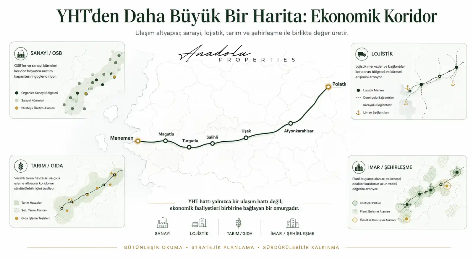
Under the Anadolu Properties approach, assessing an infrastructure project requires more than looking at where the train line passes. Station connections, new roads, the development directions of organized industrial zones, logistics investments, zoning decisions, employment, and population movements should be read on the same map. Enduring economic value often emerges not from a single project announcement, but from multiple layers of investment converging within the same micro-location.
Current Project Framework: 505 Kilometers of New Line, 624 Kilometers of Total Connection
According to the Ministry of Transport and Infrastructure’s statement dated April 3, 2026, the Ankara–İzmir high-speed rail project is being developed across the Ankara–Banaz, Banaz–Salihli, and Salihli–İzmir sections, representing approximately 505 kilometers of new works. Because the existing high-speed rail infrastructure is used between Ankara and Polatlı, new construction is concentrated beyond Polatlı; once completed, the total rail connection between Ankara and İzmir is planned to reach 624 kilometers.
The same current statement reported stations in Ankara, Eryaman, Polatlı, Emirdağ, Afyonkarahisar, Uşak, Salihli, Turgutlu, Manisa, Menemen, and İzmir. This list differs from some official announcements published in 2024 and 2025, which included points such as Alaşehir, Muradiye, Ayvacık, and Emiralem in earlier station plans. This change shows that, for investment analysis, older route or station announcements are not sufficient on their own and that the latest official plans and field statements should be verified.
According to the Ministry’s April 2026 data, the project includes 49 tunnels totaling approximately 41 kilometers, 67 viaducts totaling 26 kilometers, 78 bridges, 769 culverts, 142 overpasses, and 254 underpasses. Upon completion, approximately 11.5 million people in Ankara, Afyonkarahisar, Uşak, Manisa, and İzmir are expected to benefit directly from high-speed rail access, while the line is projected to reach an annual capacity of approximately 13.5 million passengers and 90 million tonnes of freight.
Within the Ministry of Transport and Infrastructure’s 2026 budget framework, the target announced for the Ankara–İzmir high-speed railway is completion by 2028. For investors, this timetable should not be interpreted as a guaranteed date for value appreciation; rather, it is a reference point for tracking the pace at which planning decisions, connection investments, and economic activity take shape.
Editorial data note: Station planning has changed across official statements published on different dates. This study uses the Ministry of Transport and Infrastructure statement dated April 3, 2026 as the basis for the station list and capacity figures; before any investment decision, current project, zoning, and expropriation records should be independently verified.
How Should Real Estate Be Assessed as Economic Distance Changes?
If the travel times projected by the Ministry are achieved, Ankara–Afyonkarahisar would fall to approximately 1 hour 40 minutes, Ankara–Uşak to 2 hours 10 minutes, and Ankara–Manisa to 2 hours 50 minutes, while the Ankara–İzmir journey would be reduced to 3 hours 30 minutes.
For real estate, the significance of these times is not limited to shorter journeys. A city’s economic capacity is shaped not only by its population, but also by how quickly it can reach major markets, production centers, ports, and logistics networks. When accessibility changes, business travel, supply chains, labor mobility, and commercial relationships may also evolve.
For this reason, the Ankara–İzmir line is better assessed not through land prices around individual stations, but as an economic corridor that begins in Polatlı and extends toward the production and port economy of the Aegean region.
Polatlı: The Western Gateway of the Existing High-Speed Rail Backbone
Polatlı is listed as one of the station locations in the current April 2026 statement. It is also one of the operational starting nodes of the corridor, since the new Ankara–İzmir high-speed rail works continue beyond the existing high-speed rail infrastructure used between Ankara and Polatlı.
Assessing Polatlı solely through the presence of a railway station would be incomplete. When its rail links toward Ankara–Eskişehir, Ankara–Konya, and Ankara–İzmir are considered together with road access and agricultural production functions, the district’s role as one of Ankara’s economic gateways to the west should also be monitored.
The earliest signals here may not necessarily appear in housing prices. Demand for storage and commercial space, industrial connections, road–rail integration, zoning decisions, and Ankara’s westward economic expansion may provide more explanatory indicators.
Emirdağ: An Accessibility Test for Smaller Centers
Emirdağ is identified as a station location in the current project statement. In small and medium-sized settlements, the effects of major transport investments may operate differently from those in metropolitan areas. The right question is therefore not “Will prices rise because high-speed rail is coming?” but rather how the station will connect with the existing settlement, road network, commercial areas, and future zoning development.
If new access roads, commercial uses, or planned development areas emerge, economic activity may become concentrated at specific points. However, the presence of a station alone is not sufficient. Population movement, local economic capacity, zoning decisions, and private-sector investments should be monitored together.
Afyonkarahisar: A New Layer in a Junction Economy
Afyonkarahisar may be one of the corridor’s most strategic nodes. Its importance stems not only from being located on the Ankara–İzmir route, but also from its geographic position at the intersection of road movements toward Central Anatolia, the Aegean, and the Mediterranean.
While the Ankara–Afyonkarahisar journey is targeted to fall to 1 hour 40 minutes, high-speed rail may add a new layer of accessibility to the city’s existing transport function. Increased activity in business travel, tourism, services, and intercity economic relations could also affect real estate demand indirectly.
However, in Afyonkarahisar, focusing only on the station surroundings would be insufficient. Organized industrial zones, ring roads, thermal tourism districts, the university, new residential development areas, and logistics functions should be assessed on the same analytical map.
Uşak: High-Speed Rail and Industry Should Be Read on the Same Map
Uşak is one of the centers that should be monitored closely because of its potential to bring production and transport together along the Ankara–İzmir corridor. The city’s manufacturing tradition, organized industrial structure, and position between the Aegean and Central Anatolia provide a base that could amplify the economic effects of changes in accessibility.
The Ankara–Uşak travel time is targeted to fall to 2 hours 10 minutes. From a real estate perspective, however, the more important question is where production areas and the new transport infrastructure will move closer together.
The potential impact of high-speed rail in Uşak can be assessed more reliably when the development directions of organized industrial zones, industrial plots, demand for warehousing and logistics space, connection roads, labor movements, and housing demand are examined together.
Alaşehir–Salihli: Where the Agricultural Economy Meets Logistics
As the line approaches the Aegean, the economic structure changes markedly. Agriculture, food production, and export-oriented activities stand out around Alaşehir and Salihli. Evaluating the area only through housing or land around stations may therefore miss the broader picture.
In the Ministry’s current statement dated April 3, 2026, Salihli is listed as a station, while Alaşehir, although included in earlier official station lists, is not named in the current list. This does not mean that Alaşehir will be excluded from the regional economic effects, but it does show that investment decisions should not be based on a direct station assumption.
In this section of the corridor, the processing, packaging, storage, and integration of agricultural production into export chains offer a more meaningful field of analysis. Cold storage facilities, food-processing plants, logistics areas, and the relationship between production centers and road–rail access should be monitored closely.
Turgutlu: A Station Returning to Prominence in the Current 2026 List
Current data are especially important for Turgutlu. Turgutlu was not included among the 10 stations announced in some Ministry statements from 2024 and 2025. By contrast, the most recent field statement dated April 3, 2026 lists Turgutlu as one of the station locations.
This change shows why plan information for major infrastructure projects must be tracked together with its publication date. Given Turgutlu’s location within the Manisa–İzmir industrial belt, its road connections, and its production infrastructure, the current station plan makes the region’s accessibility analysis even more important.
Even so, investment assessment should not be reduced to the station label. Industrial development, logistics demand, planning decisions, surrounding connections, and Manisa–İzmir economic integration should be monitored together.
Manisa and Muradiye: Industry, Labor, and Urban Development
Manisa is one of the corridor’s economic centers of gravity. The Ankara–Manisa travel time is targeted to fall to 2 hours 50 minutes; however, the city’s core strength comes from its existing production ecosystem rather than from the station itself.
When industry, proximity to İzmir, and road and rail connections are considered together, high-speed rail may add a new layer of accessibility. Investment analysis in Manisa should therefore not be limited to the housing market; industrial land, warehousing areas, housing demand from the workforce, commercial real estate, and İzmir–Manisa economic integration should be assessed together.
Muradiye, although included in previous official station lists, is not named in the current station list published in April 2026. Nevertheless, because of its relationship with central Manisa in terms of transport, industry, the university, and residential development, it remains an area that should be monitored at the micro level. Planning changes, new connection roads, and commercial functions may prove more decisive here than the station name itself.
Emiralem–Menemen: A North İzmir Economy Broader Than High-Speed Rail
Where the corridor reaches İzmir, the analysis extends beyond a single high-speed rail project. The northward development of the İzmir metropolitan area, the Aliağa industrial belt, the port economy, existing rail links, highways, and the İzmir–Manisa relationship converge within the same economic geography.
Menemen is listed as a station in the current April 2026 statement. Emiralem, although included in earlier official station lists, is not separately named in the current list. Emiralem should therefore be assessed not through a direct station assumption, but through the transport, industrial, logistics, and metropolitan growth dynamics of Menemen and northern İzmir.
If the accessibility increase that high-speed rail may create combines with existing industrial and logistics infrastructure, the effect could be felt not only around the station but across a broader northern İzmir economic belt. How this translates into real estate values, however, will depend on zoning plans, infrastructure investments, the supply–demand balance, and private-sector investment.
Anadolu Properties Analysis: Not a Single Signal, but a Map of Intersections
For investors, the most important message of the Ankara–İzmir High-Speed Rail Project is not the train itself, but the corridor it may create. One of the common mistakes in real estate analysis in Türkiye is to focus immediately on land prices around a major project once it is announced.
Yet enduring economic value often arises not from a single infrastructure investment, but from multiple layers of investment intersecting at the same point. The core signal set to monitor along the Polatlı–Menemen corridor can be structured as follows:
- High-speed rail station or access connection
- Expansion of organized industrial zones and new production investments
- Highway, ring-road, and connection-road projects
- Warehousing, logistics, and freight movements
- Changes in zoning plans and land-use decisions
- Employment and labor-force movements
- Population, housing demand, and pressure for commercial use
A location where only one of these elements is present may attract attention; an area where two or three intersect may warrant closer examination. When four or five different economic signals begin to overlap within the same micro-location, the possibility of transformation becomes more meaningful. Even then, this does not imply automatic value appreciation; zoning, ownership, infrastructure capacity, and market demand must still be verified separately.
This approach shifts the investor away from the question “At which station should I buy land?” toward “Which economic function is becoming stronger at which location?” That is also a more appropriate starting point for real estate analysis.
Reading the Corridor Through Three Different Economic Profiles
- Polatlı–Afyonkarahisar: Ankara’s western connection, agriculture, roads, and new rail access.
- Uşak–Salihli: production, organized industrial zones, agriculture, the food industry, and logistics.
- Turgutlu–Manisa–Menemen: intensive industry, the İzmir metropolitan economy, port connections, logistics, and labor-force movements.
The real estate effects of these three sections should not be expected to be identical. Industrial land may stand out in one area; in another, warehousing and logistics space, housing, or commercial real estate may be more relevant.
Opportunity analysis should therefore begin with economic function before asset type. Without understanding what kind of demand a region is likely to generate, looking only at price movement is not sufficient to turn an infrastructure announcement into an investment thesis.
Where Should Early Signals Be Sought?
- In connection roads and access projects before station announcements,
- In zoning and planning changes before land prices,
- In employment and labor-force movements before housing listings,
- In the expansion directions of organized industrial zones before city centers,
- In areas where new production and logistics investments are clustering before today’s population figures,
- In economic corridors between cities before individual cities themselves.
Reading the Corridor Remotely for Turkish Investors in Europe
For Turkish investors living in Europe, major infrastructure projects such as the Ankara–İzmir high-speed rail naturally attract attention. However, in a remote investment decision, the project announcement itself does not prove that a location is suitable for investment.
Considering Türkiye’s relationship with European production and supply chains, stronger transport systems linking production centers in Central Anatolia with the Aegean region’s industrial and port infrastructure could support export logistics and regional production organization over the long term. The real estate impact, however, will differ from one micro-location to another.
For this reason, analysis conducted from abroad should examine together the latest route and station information, title deed and ownership status, zoning plans, expropriation risk, valuation data, comparable transactions, organized industrial zone and logistics investments, and on-site conditions. A transport project can form part of a sound investment decision only when assessed alongside these data.
The Real Opportunity Lies Not at the Station, but Where the Data Intersect
For investors, the significance of the Ankara–İzmir high-speed rail extends beyond being able to travel from Ankara to İzmir in 3 hours 30 minutes. The central issue is how the economic distance between Ankara and the Aegean changes, and where that change intersects with production, logistics, tourism, employment, and urban development.
This process may support industrial and logistics demand in some areas and housing or commercial real estate needs in others. Yet with major infrastructure projects, the most valuable information often emerges not on opening day, but in the data generated before connection investments, planning decisions, and economic activity are widely recognized.
For investors, therefore, the right map is not simply one that shows the high-speed rail route. The right map shows where transport, production, logistics, zoning, employment, and population movements begin to intersect at the same time.
Mustafa Yılmaz
CEO – Anadolu Properties
Europe – Türkiye Investment Bridge