2026–2035 TÜRKİYE REAL ESTATE EARLY-WARNING MAP: INFRASTRUCTURE, INDUSTRY AND LOGISTICS SIGNALS ACROSS 20 DISTRICTS | RESEARCH SERIES 02
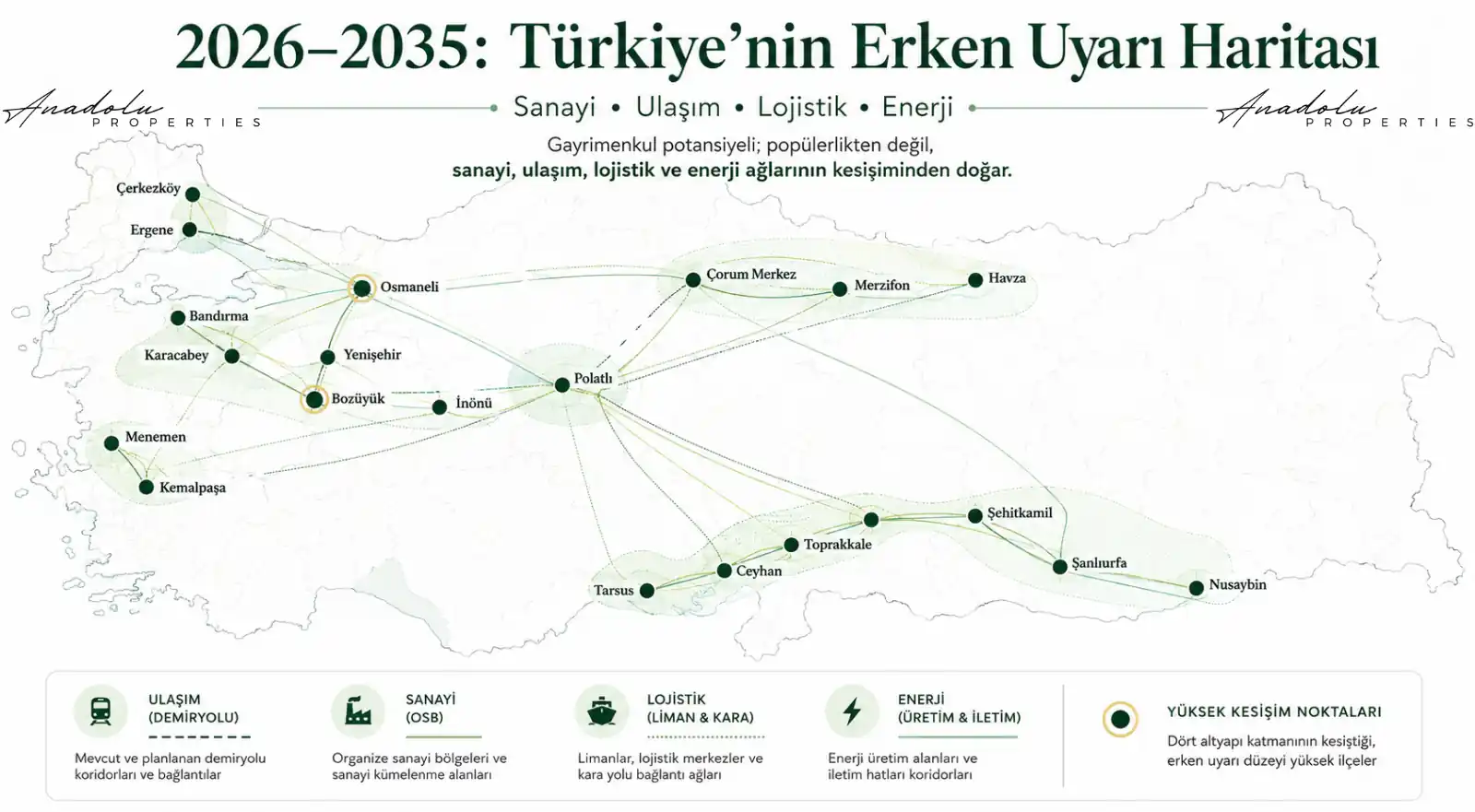
How Should the 2026–2035 Real Estate Early-Warning Map Be Read?
Major real estate potential often emerges not where everyone is already talking, but where the reasons for paying attention have not yet been fully understood.
When a motorway opens, the road becomes visible. When an organized industrial zone fills up, the factories become visible. When a railway is completed, the station becomes visible; when a logistics center becomes operational, freight flows become visible; and when the population grows, housing needs become visible. By the time these indicators are clear, the market has often already priced in at least part of the story.
For Anadolu Properties, therefore, the key question is not “Where are prices rising today?” but “In which districts are the economic movements of the next 3–10 years beginning to overlap today?”
In Türkiye in 2026, there is a strong infrastructure basis for asking this question. The Ministry of Transport and Infrastructure is tracking the Osmaneli–Bursa and Çerkezköy–Kapıkule sections within its 2026 targets, while major rail investments such as Ankara–Izmir, Mersin–Adana–Osmaniye–Gaziantep, Bandırma–Bursa–Yenişehir–Osmaneli, Halkalı–Kapıkule, Yerköy–Kayseri and Kırıkkale–Çorum are being monitored within the 2028 target framework. Ministry of Transport and Infrastructure of the Republic of Türkiye
The Ministry of Industry and Technology continuing to announce land allocations and preliminary allocations in organized industrial zones throughout 2026 also makes it possible to systematically monitor not only existing industrial zones but the directions in which industry may expand. Ministry of Industry and Technology of the Republic of Türkiye
In this study, we do not look at Türkiye through city rankings, but through the combination of district + industry + transport + energy + logistics + public investment + developable land.
This is not a list of “20 districts where land should be bought.” It is a list of 20 early-warning areas that warrant deeper research.
1. Osmaneli / Bilecik
Signal: Intersection of Marmara Industry and the Anatolian Rail Network
For many years, Osmaneli was viewed as one of Bilecik’s relatively small districts. Yet when the map is read through transport networks rather than district boundaries, a different picture emerges.
Within the Bandırma–Bursa–Yenişehir–Osmaneli High-Speed Rail Project, the Osmaneli–Bursa section is targeted for completion in the second half of 2026. The entire 201-kilometer line is planned to serve freight traffic in addition to high passenger capacity.
Osmaneli could therefore become a stronger connection point between Bursa’s industrial base, Bilecik’s production basin and the Istanbul–Ankara high-speed rail backbone.
Official source: Ministry of Transport and Infrastructure of the Republic of Türkiye
Indicators to monitor: New industrial areas, demand for logistics/warehousing, rail connections, major highway junctions and land-use decisions in the Osmaneli–Yenişehir direction.
Key risk: Proximity to the railway does not create value on its own. Agricultural status, topography, access and planning decisions must be examined at parcel level.
Why now? Osmaneli’s story is becoming more directly connected not only to Bilecik, but to Bursa’s production economy.
Early-Warning Level: High
2. Yenişehir / Bursa
Signal: Eastern Gateway of Bursa Industry
Explaining Yenişehir’s story for the coming period solely through agriculture or the airport may be incomplete. Its position at the center of the Bandırma–Bursa–Yenişehir–Osmaneli railway line distinguishes the district.
It lies in the middle of a production corridor that connects eastward to the Anatolian network through Osmaneli and westward toward Bandırma through Bursa.
Indicators to monitor: The surroundings of Yenişehir OIZ, railway connection points, the eastward expansion tendency of Bursa industry, and demand for warehousing and logistics.
Key risk: High-speed rail expectations turning into speculative pricing in some micro-locations before the infrastructure is actually delivered.
Why now? Bursa’s industrial geography is being connected to a stronger east–west rail backbone.
Early-Warning Level: Very High
3. Karacabey / Bursa
Signal: Western Gateway Between Bursa and Bandırma
If Yenişehir is Bursa’s eastern gateway, Karacabey can be read as its western gateway.
The Bursa–Bandırma section is targeted for completion in 2028. Karacabey occupies a strategic position between Bursa industry, the Bandırma port system, Balıkesir, the Izmir direction and the Sea of Marmara.
Official source: Ministry of Transport and Infrastructure of the Republic of Türkiye
Indicators to monitor: Industrial/warehousing areas, transport investments toward Bandırma, large-scale land demand and movements in logistics facilities.
Key risk: Because productive agricultural land is widespread, agricultural legislation and land-use decisions are critically important.
Why now? At Bursa’s western economic gateway, rail + road + port access could strengthen together.
Early-Warning Level: High
4. Bandırma / Balıkesir
Signal: Industry + Port + Railway
Bandırma is already more visible than many of the other districts on this list. The important issue, however, is not today’s Bandırma but the hinterland that may expand in the future.
As the Bursa rail connection reaches Bandırma, Bursa’s production capacity could become more strongly integrated with port and logistics systems on the Marmara coast.
Indicators to monitor: Port hinterland, the surroundings of Bandırma OIZ, rail freight connections and the industrial corridor toward Bursa.
Key risk: The story may already be substantially priced into certain micro-locations.
Why now? Bandırma has the potential to become not merely a port district, but one of the production gateways through which Bursa opens to the sea.
Early-Warning Level: Medium–High
5. Bozüyük / Bilecik
Signal: Anatolia’s Quiet Logistics Junction
Bozüyük’s advantage does not stem from a single megaproject, but from its existing geographic position. It lies at the intersection of the industrial systems of Eskişehir, Bursa, Bilecik, Kütahya and Marmara.
For this reason, Bozüyük should be read not only as an industrial district, but also as a multidirectional logistics connection point.
Indicators to monitor: OIZ expansions, Eskişehir–Bursa connections, warehouse investments, rail freight capacity and surrounding transport projects.
Key risk: Assuming that every plot outside the existing industrial zones has the same potential.
Why now? As production expands from Marmara toward Anatolia, the strategic value of junction points may increase.
Early-Warning Level: High
6. İnönü / Eskişehir
Signal: Western Corridor of Eskişehir Industry
İnönü is not currently a district that sits strongly on the radar of investors across Türkiye. Precisely for this reason, it deserves to be monitored for industrial and logistics indicators.
It lies west of Eskişehir, between the production systems of Bozüyük, Bursa, Marmara and Eskişehir.
Indicators to monitor: The development direction of Eskişehir OIZ, road and rail logistics, new production/warehouse demand and energy infrastructure.
Key risk: Demand remaining concentrated around the central OIZ and not spreading to İnönü to the expected extent.
Why now? As Eskişehir’s industrial capacity grows, alternative development areas to the west may become more important.
Early-Warning Level: Medium–High
7. Polatlı / Ankara
Signal: Ankara’s Western Logistics Gateway
Polatlı’s strategic value does not come from a single sector. It lies between Ankara, Eskişehir, Konya, the Izmir direction and Istanbul connections.
For this reason, reading Polatlı merely as a traditional agricultural district may become increasingly inadequate.
Indicators to monitor: OIZ activity, rail freight capacity, Ankara–Izmir high-speed rail investments, the Temelli–Polatlı production belt and energy investments.
Key risk: Because land supply is extensive, development may spread across a very wide geography, making micro-location selection more difficult.
Why now? The Temelli–Polatlı axis may become more strategic in Ankara’s westward industrial and logistics expansion.
Early-Warning Level: High
8. Çerkezköy / Tekirdağ
Signal: Türkiye’s Production Gateway to Europe
Çerkezköy is no longer a hidden industrial center. The new story is not the existence of industry, but the strengthening of rail integration with Europe.
Under the Ministry’s current targets, the Çerkezköy–Kapıkule section is expected to be completed within 2026 and the Çerkezköy–Halkalı section by 2028.
Official source: Ministry of Transport and Infrastructure of the Republic of Türkiye
Indicators to monitor: Expansion of Çerkezköy OIZ, the Kapaklı direction, rail freight traffic, and new warehouse and logistics investments.
Key risk: Current price levels are high and infrastructure expectations may already be priced into some areas.
Why now? Stronger European rail access is being added to Çerkezköy’s existing production advantage.
Early-Warning Level: High — High Pricing Risk
9. Ergene / Tekirdağ
Signal: Between the Industrial Pressures of Çerkezköy and Çorlu
Ergene’s importance comes not from the district in isolation, but from its location between Çorlu, Çerkezköy, Velimeşe and the European logistics corridor.
Indicators to monitor: OIZ occupancy, industrial expansion, water/environmental infrastructure, logistics investments and rail access.
Key risk: Water resources and environmental carrying capacity in Thrace are among the most important structural risks.
Why now? As industrial pressure continues, infrastructure carrying capacity may determine which micro-locations can genuinely grow.
Early-Warning Level: Medium–High
10. Kemalpaşa / Izmir
Signal: Izmir’s Eastern Logistics Gateway
Kemalpaşa’s future should be considered independently from central Izmir. The district lies among Izmir, Manisa, Torbalı, Aliağa and the connections toward Anatolia.
Indicators to monitor: Logistics center investments, OIZ development, rail connections, the Manisa–Izmir production relationship and warehouse demand.
Key risk: Confusing micro-locations where the industrial story is already priced in with areas that have weak infrastructure connections.
Why now? Kemalpaşa has the potential to evolve from Izmir’s hinterland into a stronger logistics node for the Aegean region.
Early-Warning Level: High
11. Menemen / Izmir
Signal: At the Center of the Izmir–Aliağa–Manisa Triangle
Menemen’s importance is not limited to Izmir’s residential expansion. Its real strategic position comes from the connection between central Izmir + Aliağa industry + the Manisa production system.
Indicators to monitor: Transport, industrial and warehouse investments toward Aliağa; Manisa connections; and energy and logistics infrastructure.
Key risk: Mixing residential expectations with industrial/logistics expectations.
Why now? It is one of the areas located at the center of the Aegean production and logistics triangle.
Early-Warning Level: Medium–High
12. Tarsus / Mersin
Signal: Junction Between Mersin Port and Çukurova
Tarsus’s strategic value is very clear on the map: Mersin Port on one side, Adana on the other, an Inner Anatolia connection to the north, and the production corridor extending toward Gaziantep to the east.
The Mersin–Adana–Osmaniye–Gaziantep high-speed rail project is also among the Ministry’s major rail investments targeted for completion by 2028.
Official source: Ministry of Transport and Infrastructure of the Republic of Türkiye
Indicators to monitor: The Yenice area, logistics zones, the impact of Çukurova Airport, the Mersin Port hinterland and rail connections.
Key risk: Unplanned price expectations on agricultural land and parcel-level access/zoning problems.
Why now? Tarsus sits simultaneously between port + air + rail + motorway + production systems.
Early-Warning Level: Very High
13. Ceyhan / Adana
Signal: Energy + Industry + Logistics
Ceyhan may be one of Türkiye’s early-warning areas that deserves close monitoring. The story here is not industry alone, but the combination of energy infrastructure + port access + pipelines + transport + large land availability.
Indicators to monitor: Energy-specialized zones, petrochemical investments, port connections, the Adana–Osmaniye railway and new industrial investments.
Key risk: Implementation schedules of large projects being extended and project-based expectations being reflected in land prices too early.
Why now? As access to energy becomes more important in industrial site selection, the industrial geography around energy production and distribution centers may become more critical.
Early-Warning Level: Very High
14. Toprakkale / Osmaniye
Signal: Small District, Major Junction
Toprakkale’s population or urban scale is not enough to explain its investment story; the map is more informative. It is located near the intersection of the directions toward Adana, Osmaniye, Gaziantep, Hatay and Iskenderun.
Indicators to monitor: Development of Osmaniye OIZ, railway, motorway, access to Iskenderun ports and logistics facilities.
Key risk: Because the district is small, demand may concentrate in limited micro-areas.
Why now? It is one of the points where a junction economy could emerge within the Southern Anatolia production corridor.
Early-Warning Level: High
15. Şehitkamil / Gaziantep
Signal: Existing Production Strengthened by New Transport Networks
Gaziantep is already one of Türkiye’s production centers. Therefore, the early signal here is not “industry will arrive”; industry is already present.
The real signal is stronger logistics access for existing industry. The development of the Mersin connection and the Development Road perspective could further reinforce Gaziantep’s role as a regional center.
Indicators to monitor: OIZ expansions, logistics facilities, freight transport toward Mersin and new transport projects toward Şanlıurfa.
Key risk: High current prices and the fact that proximity to industry does not create equal value in every micro-location.
Why now? Gaziantep’s story is evolving from production alone into a story of international logistics access.
Early-Warning Level: High
16. Şanlıurfa / Central Production Belt
Signal: Development Road + New Railway Perspective
Şanlıurfa is one of the production and logistics centers that should be monitored closely over the next decade. The analysis here should focus less on the residential market in the city center and more on industrial and transport belts.
According to statements by the Ministry of Transport and Infrastructure, project studies for the Gaziantep–Şanlıurfa–Mardin–Nusaybin–Ovaköy rail corridor have been completed and planning for the construction phase is taking shape. A new motorway between Şanlıurfa and Ovaköy is also planned within the Development Road framework.
Official source: Ministry of Transport and Infrastructure of the Republic of Türkiye
Indicators to monitor: OIZ surroundings, the Gaziantep connection, the Mardin direction, the new motorway alignment, logistics center and energy investments.
Key risk: Project implementation and financing schedules, together with extensive land supply. Project-stage and construction-stage developments should not be given the same weight.
Why now? Şanlıurfa is entering a period in which production + railway + international transit corridor layers could converge within the same story.
Early-Warning Level: Very High — High Uncertainty
17. Nusaybin / Mardin
Signal: Potential Border Economy of the Development Road
Nusaybin should be evaluated in a high-risk–high-potential category. Its location lies at the intersection of Mardin, Şanlıurfa, Iraq, Syria and east–west transport networks.
The completion of project design for the Gaziantep–Şanlıurfa–Mardin–Nusaybin–Ovaköy rail corridor makes Nusaybin relevant to long-term logistics scenarios; however, the implementation timetable and geopolitical conditions remain decisive.
Official source: Ministry of Transport and Infrastructure of the Republic of Türkiye
Indicators to monitor: Development Road alignment, rail implementation schedule, border trade, logistics centers and customs infrastructure.
Key risk: Geopolitical risk, border policies, financing and project timetable.
Why now? When major international transport corridors enter implementation, the economic function of border districts can change substantially.
Early-Warning Level: High Potential / Very High Risk
18. Central Çorum
Signal: Existing Industry + New Railway
Çorum is one of the strongest research candidates on this list. The reason is simple: production already exists, and the railway is coming.
According to the Ministry’s statement dated 5 June 2026, overall progress on the Delice–Çorum section had exceeded 25%. Tenders for the Çorum–Merzifon and Merzifon–Havza sections had also been completed.
Official source: Ministry of Transport and Infrastructure of the Republic of Türkiye
Indicators to monitor: Çorum OIZ, station/loading points, the Samsun direction, the Delice direction and new logistics investments.
Key risk: Overstating the railway effect in the short term and treating proximity to the station/alignment as an investment rationale on its own.
Why now? An Anatolian production center with an established industrial culture is being connected to a high-capacity national rail network; this is a signal that changes the accessibility of existing production.
Early-Warning Level: Very High
19. Merzifon / Amasya
Signal: Junction at the Center of the Samsun–Çorum Corridor
Merzifon has long been a strong road junction. In the new period, a railway layer may be added to this advantage.
The fact that the Çorum–Merzifon and Merzifon–Havza sections have been tendered makes the district notable within the Ankara–Samsun corridor.
Official source: Ministry of Transport and Infrastructure of the Republic of Türkiye
Indicators to monitor: OIZ, railway alignment, access to Samsun Port, road logistics and warehouse investments.
Key risk: The railway alignment and the actual industrial development areas may remain in different micro-locations.
Why now? There is a possibility that rail logistics will be added to Merzifon’s existing road advantage.
Early-Warning Level: Very High
20. Havza / Samsun
Signal: Threshold Through Which the Black Sea Port Economy Opens to Inner Anatolia
Havza could become one of the critical transition points before the Ankara–Samsun rail system reaches the Black Sea. The tendering of the Merzifon–Havza section makes this role worth monitoring more closely.
In the larger picture, the objective is not merely to connect Samsun to Ankara, but to strengthen the north–south freight system.
Official source: Ministry of Transport and Infrastructure of the Republic of Türkiye
Indicators to monitor: Railway alignment, OIZ, Samsun Port hinterland, energy investments and warehouse/logistics demand.
Key risk: Expectations being excessively reflected in land prices before they are realized.
Why now? Havza could become one of the gateways between Samsun Port and the Inner Anatolian production system in the future.
Early-Warning Level: Very High
What Do We See When We Look at the 20 Districts Together?
The key result is not the list, but the pattern.
Similar combinations recur across many of these districts:
- Existing production + new transport
- Existing logistics + new industry
- Energy + large land availability + transport
- OIZ + railway + port access
In other words, the investment signal does not come from a single project. It comes from multiple economic and physical layers overlapping in the same geography.
Anadolu Properties Early-Warning Formula: 8 Data Layers
- Industrial Signal: A new OIZ, OIZ expansion, land allocation or preliminary allocation activity. Regular OIZ allocation announcements in 2026 make this data easier to monitor systematically.
- Transport Signal: A new motorway, railway, junction, ring road or rail spur.
- Logistics Signal: Port access, freight terminal, logistics center, customs or warehousing cluster.
- Energy Signal: Substation capacity, energy generation, high-voltage infrastructure and new energy investments.
- Public Investment Signal: Expropriation, investment programs, TOKİ, hospitals, universities or major public facilities.
- Private-Sector Signal: Factory, data center, warehouse, energy facility or large-scale corporate land demand.
- Demographic Signal: Changes in migration, employment, working population and housing need.
- Parcel Signal: Zoning, road frontage, size, geometry, agricultural status, topography and expansion potential.
Which Districts Stand Out in Research Priority?
In terms of current project density and intersecting economic layers, the following areas stand out on the first research radar:
Tarsus: Port + airport + motorway + railway + Çukurova production system.
Ceyhan: Energy + industry + port access + railway.
Çorum: Existing industry + advancing railway investment + Samsun Port perspective.
Merzifon: Road junction + OIZ + newly tendered railway sections.
Yenişehir: Bursa industry + Osmaneli connection + Bandırma corridor.
Şanlıurfa: Production + Development Road + completed railway project design; but with high implementation uncertainty.
Polatlı: Intersection of the Ankara + Eskişehir + Konya + Izmir transport systems.
“The strongest early signal” and “the best investment” are not the same thing. Once price, legal status, zoning, agricultural status, infrastructure cost, liquidity and parcel characteristics enter the analysis, the ranking may change completely.
How Should an Area That Is Not Yet Fully Priced Be Researched?
The most difficult stage of real estate intelligence is not identifying the district, but translating the change in economic accessibility within that district down to parcel level.
Finding the district is not enough. The neighborhood must be found. The neighborhood is not enough either. The parcel must be found.
Land directly opposite an existing OIZ gate may already be priced with very high expectations. By contrast, another micro-location in the OIZ’s planned expansion direction, where real road and infrastructure connections could be established, may not yet attract the same level of attention.
Similarly, the area around an existing station may be expensive, while the corridor that will functionally connect to a new freight terminal or rail spur could emerge in a different location. Today’s motorway exit may already be priced in, whereas the junction that will connect to a new ring road may not yet attract the same demand.
Therefore, the purpose of the early-warning system is not to find cheap land. It is to identify land whose economic accessibility may change in the future before that access changes, and then test this hypothesis against official plans and parcel data.
The Next Stage: From District to Parcel
Traditional real estate research in Türkiye often follows the line “Province → district → price.” A data-driven approach requires a broader decision chain:
Macroeconomy → Capital movement → Public investment → Energy
Industry → Railway / motorway → Logistics → District
Neighborhood → Block → Parcel
Value + Risk + Liquidity + Future Potential
Real estate intelligence truly begins when the macro story can be verified at block-and-parcel level with legal, technical, zoning, market and liquidity data.
Major Risk: Buying the Project Story Instead of the Project
One of the most important mistakes in land investment in Türkiye is to assign the same weight to projects that are at very different stages of realization.
- “The train will pass through here.”
- “An OIZ is coming here.”
- “A road will be built here.”
- “This will become a logistics center.”
- “A factory is coming here.”
None of these statements is an investment rationale on its own. A project’s official status, financing, tender, alignment, expropriation, planning decisions, implementation schedule and actual effect on the parcel must each be investigated separately.
For example, the fact that overall progress on the Delice–Çorum section had exceeded 25% as of 5 June 2026 is a stronger implementation signal than a line still only at project/design stage. Ministry of Transport and Infrastructure of the Republic of Türkiye
The New Real Estate Question for 2026–2035
In the coming period, the question investors may need to ask is not “Where is there cheap farmland?” but “Where is economic accessibility changing?”
Because a plot’s potential is determined not only by the land itself, but by its access to energy, industry, labor, ports, railways, motorways, data and markets.
For this reason, the scarce resource of the future may not be land alone. Land that is connected to the right infrastructure and is legally and technically usable may become more critical.
Reading Economic Movement, Not Just the Map
Türkiye’s 2026–2035 investment map will not consist solely of today’s city rankings. The new economic geography may take shape through emerging connections extending from Bursa to Osmaneli, from Eskişehir to Polatlı, from Mersin to Ceyhan, from Gaziantep to Şanlıurfa, and from Çorum through Merzifon and Havza to Samsun.
Therefore, the task of the future investor is to track, before price appreciation, the movement that could affect prices and the quality of that movement’s realization.
Not the road, but the economy the road connects.
Not the OIZ itself, but the direction in which the OIZ is expanding.
Not the railway, but where freight will move from and to.
Not the port, but the port’s expanding hinterland.
Not the city, but the economic intersection.
And finally: the right parcel located on that intersection.
The future of real estate intelligence lies in moving from measuring today’s price to detecting tomorrow’s movement early, and then verifying that movement through official data, field information and block-and-parcel analysis.
Anadolu Properties
Turning data into insight, and insight into investment decisions.
This study has been prepared for general information and regional research purposes. The “early-warning level” is not a forecast of value appreciation or investment advice; it refers to the relative concentration of infrastructure, industrial and logistics signals that warrant more detailed research in the relevant area. Project schedules, alignments and planning decisions may change. Every property must be assessed separately at block-and-parcel level through legal, technical, zoning, market, liquidity and risk analysis.
Mustafa Yılmaz
CEO – Anadolu Properties
Europe – Türkiye Investment Bridge