Türkiye’s New Axes | #15 İYİDERE LOGISTICS PORT AND THE ECONOMIC USE OF REAL ESTATE
How Should We Assess İyidere Port’s Economic Impact?
To understand İyidere Logistics Port’s impact on real estate, we need to examine maritime capacity alongside usable inland connections. Proximity to the port alone does not establish suitability for logistics, new development rights or an increase in value. Our central question is which economic activities this investment could bring to which properties.
Settlements along the eastern Black Sea coast and the mountainous terrain behind them shape the relationship between transport and logistics. We assess İyidere within this geography; the Ministry places it approximately 20 kilometres from central Rize and 50 kilometres from central Trabzon. Heavy vehicle standards, gradients, costs and continuity of access matter as much as the presence of a road on a map.
Reported Progress and Capacity at İyidere Logistics Port
The Ministry of Transport and Infrastructure’s announcement of 17 August 2026 reports 82% physical progress. It also gives figures of 2,950 metres for the main breakwater, 395 metres for the secondary breakwater, 2,220 metres of quay and approximately 657,000 square metres of port backland. These project indicators must be read in the context of the announcement’s date and scope.
Annual capacity targets are stated as 3 million tonnes of general cargo, 8 million tonnes of bulk cargo, 100,000 TEU of containers and 100,000 vehicles for Ro-Ro transport. Tonnes, TEU and vehicles are different units and cannot simply be added to produce a single capacity figure. Target capacity is not actual cargo throughput. Source: Ministry of Transport and Infrastructure, 17 August 2026.
We must also read the timetable in its historical context. The Ministry’s announcement of 11 October 2025 gave the third quarter of 2026 as the completion target. The more recent announcement of 17 August 2026 targets completion of infrastructure before year-end, followed by the start of superstructure works. We do not treat the earlier target as an actual opening date. Source: Ministry of Transport and Infrastructure, 11 October 2025.
In this review dated 24 October 2026, the detailed official progress announcement we located is the 82% figure dated 17 August. The sources reviewed do not confirm that all infrastructure has been completed or that commercial cargo operations have begun. We therefore monitor physical progress, completion of infrastructure and superstructure, and the start of commercial operations as separate stages.
İyidere Port Zoning Plans and Property Use Rights
According to the Rize Provincial Directorate of Environment, Urbanisation and Climate Change’s announcement of 11 June 2026, the Ministry approved the additional and revised port master zoning plan at 1:5,000 scale and the additional and revised implementation zoning plan at 1:1,000 scale on 3 June 2026. The plans were placed on public display for 30 days on 11 June. The announcement cites Article 7 of Coastal Law No. 3621 among its legal bases. Source: Rize Provincial Directorate of Environment, Urbanisation and Climate Change, 11 June 2026.
This is a planning decision concerning a specific port area. It does not grant logistics or commercial use rights to all surrounding privately owned properties. The end of the public display period alone does not establish the plan’s subsequent legal status; any objections, amendments and current plan sheets must also be examined.
At Anadolu Properties, we do not limit parcel assessment to a news report. Plan sheets, planning provisions and current parcel boundaries must be read together. Before considering a property’s distance from the port, we investigate whether the project changes its legally permitted use.
657,000 Square Metres of Port Backland and Demand Beyond the Port
The approximately 657,000 square metres of backland is the operational area announced by the Ministry as part of the port project. We cannot interpret the entire area as warehouse, industrial or commercial land to be offered on the market. The port’s own land and surrounding privately owned properties require separate assessment.
The backland may accommodate functions such as cargo handling, temporary storage and transport organisation. The functions planned and their scale must be established through approved plans and operational designs. If capacity within the port meets certain needs, demand for new facilities outside it may remain limited; the operating model and cargo types may also create a need for other external services.
We therefore do not predict today which neighbourhoods outside the port will see warehouse demand, how many square metres will be needed or where prices will rise to. We examine the relationship between the port’s own capacity and additional property needs beyond its boundaries.
Logistics Access Along the Rize–İkizdere–İspir–Erzurum Route
We consider İyidere’s inland connections through the Rize–İkizdere–İspir–Erzurum axis. The General Directorate of Highways’ 2026 Performance Programme lists the Rize–Erzurum–Bingöl–Diyarbakır route among north–south road corridors. This framework shows why the port should be examined within a wider transport network, as well as at district level. Source: General Directorate of Highways, 2026 Performance Programme.
The existence of a corridor does not show that every section has been completed to the same standard or will carry all future port cargo without difficulty. Heavy vehicle capacity, tunnels and connecting roads, journey time reliability, winter access, transport costs and port entry and exit arrangements must be examined together. We investigate economic impact through the practical usability of these connections.
The Port’s Two Gates
In this article, we use “the port’s two gates” as an analytical framework that examines maritime cargo acceptance capability together with inland logistics access and the conditions for economic use. It is neither a value appreciation multiplier nor a calculated investment score.
The Maritime Gate
The maritime gate is the port’s ability to serve ships and cargo. Quay length, water depth, breakwaters, handling systems, container and bulk cargo capacity, and Ro-Ro services determine this capability. Technical capacity alone does not prove that new property demand has emerged nearby.
The Inland Gate
The inland gate is the ability to move cargo between the port and economic activities. Road connections, entry and exit capacity, storage and transfer facilities, inland access, logistics operators and properties’ legal use conditions are decisive here.
The ability to accommodate large ships does not eliminate landside cost and capacity problems. Strong inland connections alone cannot generate the expected logistics demand if sufficient commercial cargo traffic does not materialise. When examining the impact on real estate, we ask whether both gates work together.
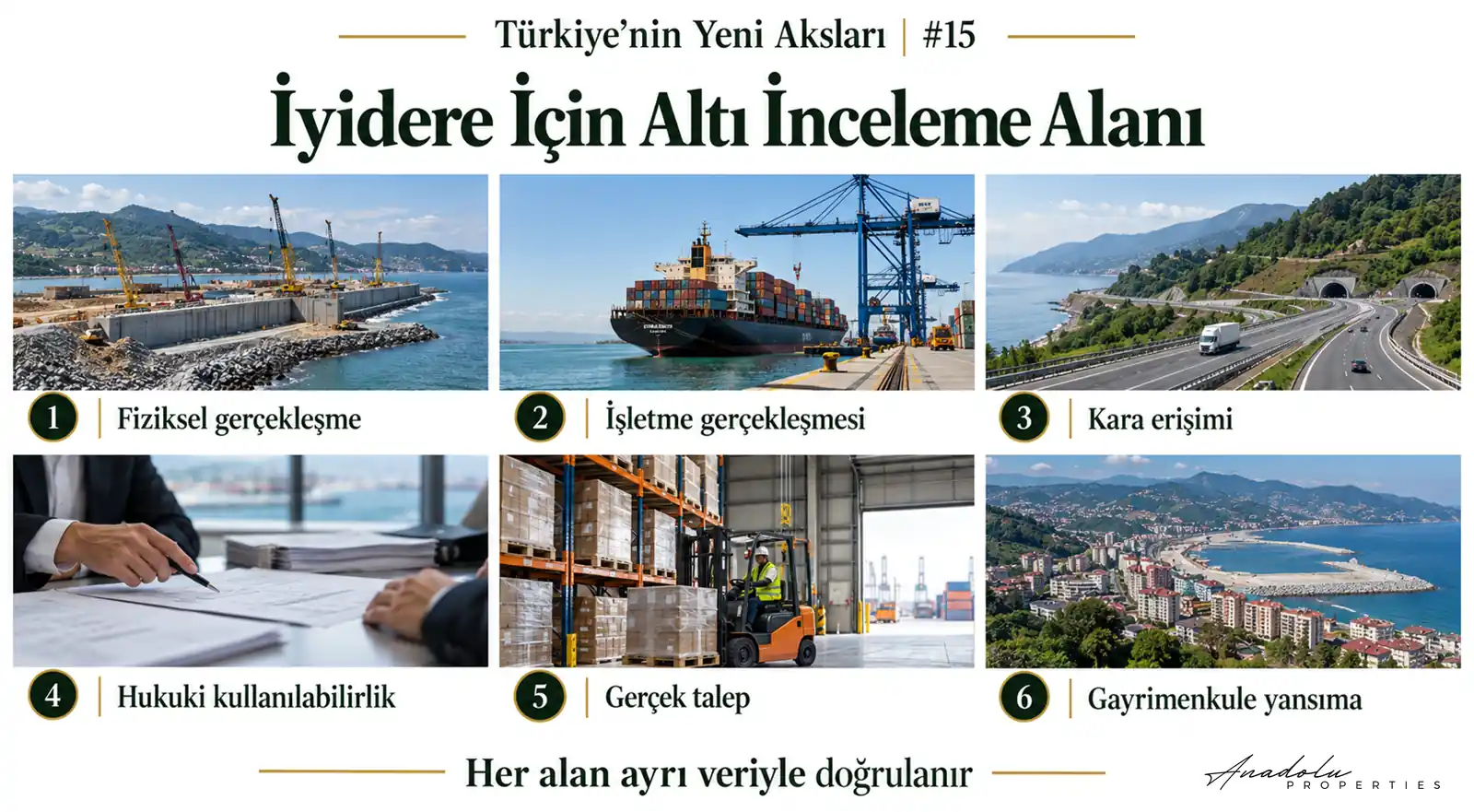
Six Areas for Assessing the Impact on Real Estate
1 Physical Progress
Which structures are complete, which are under construction and which works have not begun? Assessing the reported progress rate alongside the project’s scope prevents the completion of one structure from being confused with completion of the entire port.
2 Operational Delivery
Has the port begun commercial operations, which cargoes does it accept and are there regular shipping services? Announced capacity and actual throughput must be monitored separately.
3 Inland Access
Which roads provide entry and exit, is heavy vehicle access suitable and are there bottlenecks? Progress on planned road improvements helps assess the route’s usability.
4 Legally Permitted Use
Are the necessary planning decisions in place for warehouses, bonded warehouses, logistics facilities or commercial use? Zoning, ownership, expropriation, coastal legislation and conservation decisions must be examined property by property.
5 Actual Economic Demand
New facilities established by logistics companies, completed warehouse lettings, changes in industry’s transport choices, employment and service demand must be monitored. Expectations and actual operating decisions should not be used interchangeably.
6 Effects on Real Estate
Are uses and permits changing? Is there a measurable difference between comparable properties in completed sales and lettings? These data allow us to assess infrastructure’s economic impact more reliably.
Comparing Two Properties Near the Port
Imagine one property 700 metres from the port, without suitable zoning conditions for a logistics facility and with limited heavy vehicle access. A second property is 8 kilometres away, with a suitable road connection, the necessary development conditions and technical characteristics.
The second property may be more functional for a particular logistics operator. This is an illustrative assumption, not a valuation or price comparison of actual properties. Use rights, technical suitability, access and actual demand must be assessed alongside distance.
Ground Conditions and Natural Hazards in the Eastern Black Sea Region
Rize AFAD’s announcement of 9 September 2026 reports that the Provincial Disaster Risk Reduction Plan workshop addressed natural hazards, particularly landslides and flooding. This provincial assessment alone does not demonstrate that a specific parcel in İyidere is at risk; it highlights the importance of geological and hydrological conditions in property assessment. Source: Rize Provincial Directorate of Disaster and Emergency Management, 9 September 2026.
For large warehousing and logistics facilities, ground bearing capacity, slope stability, flood hazards, drainage, heavy vehicle access and necessary engineering costs must also be investigated. We do not regard a property as suitable for logistics investment solely because it is near the port; safety and legally permitted use are also part of the assessment.
Three Distinct Areas of Impact for Anadolu Properties
The first is the port’s own operational area, where operating needs and approved planning decisions are decisive. The second is the immediate surrounding area with direct port access, where existing use rights, transport and technical characteristics become important. The third is the inland logistics route, where we investigate which production centres establish actual commercial relationships with the port.
We do not assume that these areas will experience the same economic impact. A nearby property may be unusable because of planning or access restrictions, while an existing industrial or logistics facility farther away may benefit from a new transport option. This possibility must also be verified with actual data.
In the period ahead, we will monitor official infrastructure completion, the start and progress of superstructure works, the commercial opening, initial cargo operations and actual throughput. Port entry and exit connections and road investments along the Rize–İkizdere–İspir route will form the transport dimension of this monitoring.
Current zoning plans, new warehouse and bonded warehouse permits, logistics facility permissions, and completed sales and lettings will also inform property assessment. Flood, landslide, ground and ownership risks will be assessed at parcel level. We will use these data to define the area of economic impact without treating demand that has yet to emerge as established demand.
From Port Capacity to Actual Property Use
Reported construction progress, capacity targets and port planning decisions in İyidere provide a concrete starting point for research. Understanding the economic impact requires monitoring the transition to commercial operations, cargo types, transport routes and the needs that the port’s own backland will meet.
The question we explore in part 15 of Türkiye’s New Axes is: which properties could this capacity bring into actual economic use? We seek an answer by examining how cargo entering the port’s maritime gate connects through its inland gate to production, trade and property use.
This study has been prepared for general information and research purposes. Capacity targets are not actual cargo traffic or commercial performance. Properties’ zoning, ownership, coastal legislation, natural hazards, technical infrastructure and economic use conditions must each be verified. Proximity to infrastructure does not guarantee value appreciation or new development rights.
Mustafa Yılmaz
CEO – Anadolu Properties
Europe–Türkiye Investment Bridge