THE INVESTMENT MAP OF THE FUTURE | #01 PORT HINTERLANDS IN TÜRKİYE: LOOK BEYOND THE PORT, NOT JUST BESIDE IT
Port Hinterlands: A Port Is Not a Point, but an Economic Sphere of Influence
On a map, we see a port as a point. In the economy, however, a port is much more than a single point: it is a sphere of influence that connects production, storage, distribution and transport networks.
The true strength of a port is related not only to how many vessels call at it, but also to the quality of the geography behind it. If industrial zones, warehouses, railways, highways, logistics centers, energy facilities, free zones and production clusters operate within the same system, the port’s economic impact can extend tens of kilometers inland from the coast.
In logistics literature, this area is defined as the hinterland. From a real estate perspective, however, interpreting the hinterland merely as “the area served by the port” may be insufficient. The key issue is where cargo turns into economic activity after it comes ashore.
When an automobile factory’s port connection improves, it is not only the port that benefits. The logistics function of the industrial area where the factory is located may strengthen; demand for storage and transshipment may increase; new suppliers may arrive; and a highway interchange or rail freight terminal may become more critical.
For this reason, the investor’s first question should not be “How many kilometers is it from the port?” A more meaningful question is: “In which direction is this port’s economic influence moving, and at which connection points is cargo concentrating?”
There Is Another Economic Map Behind Türkiye’s Port Map
Türkiye’s port economy has reached a considerable scale. According to data from the Ministry of Transport and Infrastructure, the amount of cargo handled at ports increased by 4% in 2025 to 553,268,303 tonnes, reaching the highest level in the history of the Republic. Container throughput was approximately 14 million TEU.
Growth continued in January–June 2026: cargo handled increased by 1.5% year on year to 279.1 million tonnes, while container throughput rose by 1.3% to more than 7 million TEU.
Reading these figures only as maritime trade statistics may obscure the main transformation on the land side. Millions of tonnes of cargo come to a port from somewhere; after leaving the port, they move toward factories, warehouses, distribution centers, rail terminals or other transport modes.
For real estate investment analysis, the critical issue is to understand in which corridors this freight movement creates permanent economic functions.
Aliağa: What Do We See 70 Kilometers Behind the Port?
Aliağa is one of the strongest examples in Türkiye for understanding this approach. In 2025, 89.5 million tonnes of cargo were handled at facilities within the jurisdiction of the Aliağa Regional Port Authority. Approximately 81.5% of this consisted of international cargo movements.
However, if we assess Aliağa only through the port facilities on the coast, we miss the bigger picture. When we pull the map back, we see that Aliağa, Menemen, Kemalpaşa, Manisa and İzmir’s industrial belt are connected within the same production-logistics system.
Within this system, the Kemalpaşa Logistics Center provides a particularly useful example. The Ministry of Transport and Infrastructure states that more than 15 industrial zones and all of İzmir’s ports are located within an approximately 70-kilometer radius as the crow flies. The center is 71 kilometers from Alsancak Port by rail and is connected to the existing conventional railway network by a rail siding.
The Ministry also envisages Kemalpaşa serving not only İzmir, but also trade in Manisa, Denizli and Aydın. This example shows that a port economy can operate together with logistics and industrial nodes located tens of kilometers inland from the coastline.
The main conclusion is therefore clear: in port-related real estate, distance alone is not decisive; functional connectivity matters more. One site may be 10 kilometers from a port yet remain outside the freight flow. Another may be 60–70 kilometers away but still form part of the port’s true hinterland because of its access to rail, highways and industry.
Bandırma: What Changes When the Port and Bursa’s Industry Move Closer Together?
A different hinterland model is emerging in Bandırma. Behind the port lies Bursa, one of Türkiye’s strongest production centers.
The Bandırma–Bursa–Yenişehir–Osmaneli high-speed rail and railway project is being developed over 201 kilometers. The Ministry of Transport and Infrastructure states that the full line is planned to have capacity to serve approximately 59 million tonnes of freight traffic annually.
Reading this project only as high-speed rail coming to Bursa pushes the freight dimension into the background. The broader economic connection is: Bursa production → rail → Bandırma → maritime transport.
As this connection strengthens, the hinterland of Bandırma Port may no longer be limited to the Balıkesir area. Bursa’s automotive, machinery and manufacturing ecosystem could establish a more direct relationship with the port. In such a scenario, the critical area for investors is not only the coastline, but where production, storage, transshipment and logistics functions concentrate between Bandırma and Bursa.
Tekirdağ: When There Is a European Corridor Behind the Port
The equation is different again in Tekirdağ. In 2025, approximately 2.14 million TEU of containers were handled at facilities within the jurisdiction of the Tekirdağ Regional Port Authority. This volume makes Tekirdağ one of Türkiye’s strongest container clusters.
Yet Tekirdağ’s hinterland strength is not only maritime. Behind it lie dense industrial areas such as Çorlu, Ergene and Çerkezköy, followed by Kapıkule and the connection to Europe.
The operation of scheduled freight trains in both directions on the Çerkezköy–Kapıkule section of the Halkalı–Kapıkule Railway Line in June 2026 shows that this connection is no longer merely a line on a project map. One of the services on 17 June 2026 ran from Çerkezköy to Edirne with 18 wagons and 1,310 tonnes of cargo.
Within this framework, Tekirdağ’s ports, the Çorlu–Ergene industrial belt, Çerkezköy and Kapıkule can be read as parts of the same economic system. The real estate question therefore changes as well: is the land closest to the sea more strategic, or is it the right logistics node where industry intersects with the European corridor?
İskenderun: When Port, Industry, Energy and Rail Come Together in One System
The Gulf of İskenderun offers another model. In 2025, approximately 70.9 million tonnes of cargo were handled at facilities within the jurisdiction of the İskenderun Regional Port Authority, placing the region third after Aliağa and Kocaeli.
However, the economic system behind the port is much broader: the production belt spanning Hatay, Osmaniye, Adana, Ceyhan, Yumurtalık and Gaziantep can be considered part of the same logistics geography.
Under the World Bank-financed Rail Logistics Improvement Project of the Ministry of Transport and Infrastructure, new rail siding connections are being developed between industrial areas in the Çukurova Region and ports in the Gulf of İskenderun. The project’s main objective is to strengthen OIZ–port and OIZ–mainline connections and increase the share of industrial production that can be transported by rail.
This structure represents something broader than a simple “the port is growing” narrative: the port + industry + energy + rail system is becoming more strongly interconnected. From a real estate perspective, the important issue is to track at which nodes this network creates demand for storage, production, transshipment and service functions.
Samsun: Could a Black Sea Port Become a Gateway to Central Anatolia?
Samsun should be monitored for a different reason. Behind the port lies not only the Black Sea hinterland, but also the possibility of a stronger north–south connection with Central Anatolia.
The Ministry of Transport and Infrastructure’s 2025 Activity Report recorded that the Gelemen–Tekkeköy rail siding had been completed and was planned to enter operation in 2026. In a January 2026 Ministry statement, it was also noted that the approximately 7-kilometer line had been completed and that the Gelemen and Tekkeköy logistics centers had been integrated.
At the same time, development of the Ankara–Kırıkkale–Çorum–Samsun railway connection is also important for the north–south logistics backbone. As these connections strengthen, the economic sphere of influence of Samsun Port may extend beyond industrial zones around Samsun and establish stronger links with Havza, Merzifon, Çorum and, over the longer term, production in Central Anatolia.
For this reason, measuring port hinterland in the future by travel time, freight cost and the quality of intermodal connections may be more meaningful than measuring it in kilometers.
Mersin: Behind the Port Is Not One City, but a Production Corridor
Mersin is one of the clearest examples of the idea of “looking behind the port.” Behind the port lies not a single city, but a powerful production and logistics belt extending along the Tarsus → Adana → Ceyhan → Osmaniye → Gaziantep axis.
When this corridor is considered together with rail and highway investments, Mersin Port’s hinterland can become a production geography extending hundreds of kilometers inland. For this reason, evaluating the port economy only through coastal commercial real estate or plots closest to the port excludes a significant part of the system.
Sometimes the most strategic real estate in a port economy is not beside the port, but at the point where cargo is consolidated before entering the port, separated after leaving it, or transferred between different transport modes.
A Framework for Real Estate Investment Analysis: The “Hinterland Premium”
Within this series, I use the concept of a “hinterland premium” as an analytical framework.
Here, the hinterland premium refers to the strategic locational advantage that may arise not from a property’s physical proximity to a port, but from its functional access to the economic flow between the port and the production and distribution system. It is not an academic or official valuation standard; it is a working concept used to think about location analysis more systematically.
The concept certainly does not imply a guarantee of price appreciation. Nor does it produce an automatic conclusion such as “land near a port will appreciate.”
Consider two plots. The first is 8 kilometers from the port, but has no rail connection, weak heavy-vehicle access, limited industrial functionality and little scope for expansion. The second is 45 kilometers from the port, but is adjacent to an OIZ, close to a highway interchange, can access a rail freight terminal, has strong energy infrastructure and is more suitable for large-scale warehouse uses.
It is impossible to understand which of these two properties has the stronger relationship with the port economy by measuring kilometers alone. The hinterland premium is intended precisely to question this functional connectivity.
What Early Signals Appear Before Value Forms in a Port Hinterland?
The strengthening of a port hinterland may be read before prices move through certain physical, administrative and economic developments. In particular, if several of the following signals appear together, deeper analysis is warranted:
- A new rail siding or freight terminal investment
- A new logistics center or intermodal transfer area
- Expansion of an OIZ or creation of new industrial plots
- A new highway connection, interchange or heavy-vehicle access route
- An increase in port capacity or a significant change in cargo type
- New warehouse, bonded warehouse, cold-chain or distribution-facility investments
- Growth in energy capacity and infrastructure upgrades serving industry
- A major manufacturing facility, supplier cluster or free-zone expansion
- Expropriation, planning changes and transport-corridor decisions
Türkiye’s rail-siding policy is particularly important in this respect. In a statement dated 23 November 2025, the Ministry of Transport and Infrastructure reported 287 rail sidings on the national rail network with a total length of 445.8 kilometers. Under the 12th Development Plan, the 2028 target is 608 kilometers.
Because official publications may report different total-length figures depending on the period and reporting definitions used, a healthier investment-analysis method is to track, project by project, which new line connects which OIZ, port, factory or logistics center rather than relying only on one aggregate number.
These lines provide an important physical signal: at which points is the public sector prioritizing the connection of industrial freight to the main rail network? In real estate research, the answer to this question may be one of the indicators that can be read before price movements.
Not Every Port Expansion Is a Real Estate Opportunity
Particular caution is required here. Growth at a port does not mean that every parcel around it will become strategically important.
A property may be located in an agricultural protection area; be subject to environmental restrictions; connect to the transport network from the wrong side; fall within an expropriation zone; lie outside the direction of industrial expansion; be unsuitable for heavy-vehicle traffic; or already have market expectations fully reflected in its price.
The nature of the cargo handled at the port also matters. The land-side real estate requirements created by a port dominated by energy cargo may differ substantially from those of a container-focused port. Bulk cargo, containers, Ro-Ro, petrochemicals, automotive cargo and agricultural products create different requirements for storage, security, access and land.
Therefore, saying “the port is growing” is not investment analysis in itself. The real questions are: What is growing? Where is the cargo coming from, where is it going, and what economic activity does it generate on the land side?
If a property is to be evaluated as an investment, port and logistics data should be assessed together with zoning status, ownership structure, planning decisions, actual access, environmental constraints, infrastructure capacity, comparable transactions and valuation data.
Anadolu Properties Perspective: Read the Cargo’s Footprint on Land, Not Just the Coastline
At Anadolu Properties, when we analyze port investments, we do not begin with real estate at the port gate. We first try to understand how the cargo moves after it leaves that gate.
We believe three questions are particularly important in determining a port’s true economic sphere of influence:
Where is production located?
Which route does the cargo come from, and in which direction is it distributed?
Where do different transport modes connect?
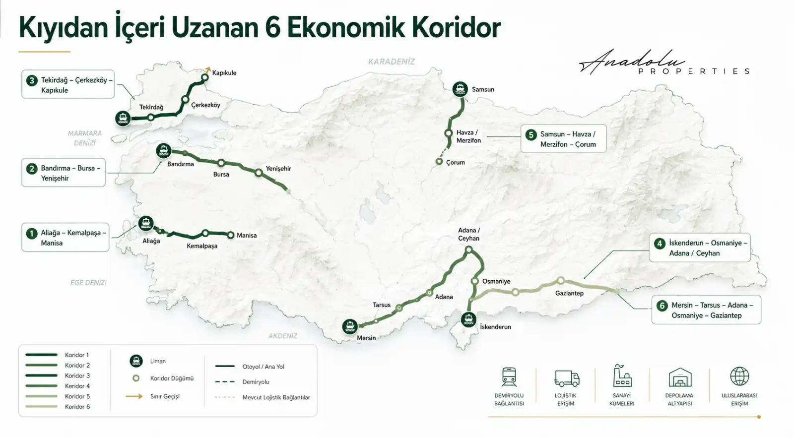
Within this framework, we believe the following corridors should be monitored not as individual port or transport projects, but as interconnected economic systems:
Aliağa – Menemen – Kemalpaşa – Manisa
Bandırma – Bursa – Yenişehir
Tekirdağ – Çorlu – Ergene – Çerkezköy – Kapıkule
İskenderun – Osmaniye – Adana / Ceyhan
Samsun – Havza / Merzifon – Çorum
Mersin – Tarsus – Adana – Osmaniye – Gaziantep
The aim here is not to say “these regions will appreciate.” What we are looking for are early and verifiable signals that warrant deeper investor research.
If port capacity is expanding, rail connectivity is strengthening, OIZs are growing, energy infrastructure is improving, warehouse demand is emerging and new production facilities are beginning to cluster in the same geography, there may be more than a port investment there; a new economic hinterland may be taking shape.
Our approach is therefore to follow not the coastline, but the trace cargo leaves on land. Over the long term, the strategically important location may not be the parcel closest to the port gate, but the property positioned at the right point in the economic flow between port and production.
The Main Question for Investors: Where Is the Cargo Moving?
More than 553 million tonnes of cargo moved through Türkiye’s ports in 2025, and growth continued in the first half of 2026. For a real estate investor, however, the main issue is not total tonnage alone. It is where the cargo goes.
The focus should be not on where the ship berths, but on the direction cargo moves once it comes ashore; not on the port gate, but on the logistics center; not on the coastline, but on the OIZ; not on distance, but on connectivity; not on a single city, but on the hinterland.
Some of the important real estate movements of the future may not begin immediately beside the sea. They may emerge 20 kilometers inland, 50 kilometers inland, or within a connection system spanning dozens of kilometers, as in the Aliağa–Kemalpaşa example.
For this reason, when reading the investment map of the future, a port should not be seen as a point on the map, but as an economic sphere of influence together with the production, logistics and transport networks extending behind it.
And the core conclusion of this article can be summarized in one sentence: “The port is where the ship stops. Value, however, often forms where the cargo keeps moving.”
Data verification note: Port cargo and container data have been updated on the basis of the General Directorate of Maritime Affairs; railway, rail-siding and logistics-center information is based on official statements from the Ministry of Transport and Infrastructure / AYGM.
Mustafa Yılmaz
CEO – Anadolu Properties
Europe – Türkiye Investment Bridge