TÜRKİYE’S NEW CORRIDORS SERIES 03 | MERSIN–ADANA–OSMANIYE–GAZIANTEP HIGH-SPEED RAIL CORRIDOR: WHERE IS THE NEW INDUSTRIAL AND LOGISTICS MAP TAKING SHAPE?
WHY IS THE 37.1 MILLION-TON FREIGHT TARGET CRITICAL?
Competition in global trade is no longer shaped solely by who can produce at the lowest cost. How quickly production centers connect to ports, factories’ access to rail and motorway networks, and the time and cost required to move freight to global markets via alternative routes are becoming increasingly decisive.
Europe’s efforts to diversify its supply chains, the growing strategic importance of the Middle Corridor, and projects such as the Development Road, which is planned to extend from the Persian Gulf through Türkiye to Europe, require the production and logistics geography of southern Türkiye to be assessed from a broader perspective.
One of the key components of this broader picture in Türkiye is the Mersin–Adana–Osmaniye–Gaziantep High-Speed Railway Line. According to the Ministry of Transport and Infrastructure’s statement dated 26 May 2026, the project is 312.5 kilometers long and is being developed as an electrified, signaled line suitable for both passenger and freight transport, with a design speed of 200 kilometers per hour for passenger trains. The same statement maintained the target of carrying an average of 3.1 million passengers and approximately 37.1 million tons of freight per year, while noting that overall physical progress on the project had exceeded 87%.
Under the current plan, the rail distance between Mersin and Gaziantep is intended to decrease from 361 kilometers to 312.5 kilometers, while the journey time is targeted to fall from 6 hours 23 minutes to 2 hours 15 minutes. For investors, however, perhaps the most critical figure is not the journey time but the annual freight target of 37.1 million tons.
Passenger movement primarily changes accessibility. Freight movement, however, can have a more direct influence on production, warehousing, distribution, and industrial location decisions. The economic story of the line is therefore less about people traveling faster from Gaziantep to Mersin and more about how the cost, capacity, and time required to connect Southeastern Anatolia’s production capacity to Mediterranean ports may change.
It is more meaningful to view the corridor not as the sum of individual cities, but as a complementary economic system: Gaziantep represents production and export capacity, Osmaniye its transit and industrial function, Adana the combination of production, agriculture, and logistics, and Mersin the port and foreign-trade gateway.
MERSIN: THE CORRIDOR’S GATEWAY TO THE SEA
To understand the economic logic of this line, the starting point should be Mersin Port. According to the Ministry of Transport and Infrastructure’s statement dated 6 January 2025, the port covers approximately 124 hectares, making it one of Türkiye’s largest port areas, and serves an extensive hinterland reaching roughly half of the country.
The Mersin Port Expansion Project aims to increase container capacity from 2.6 million TEU to 3.6 million TEU. Growth in port capacity and stronger rail capacity connecting the hinterland to industrial cities should be viewed as two components of the same economic system.
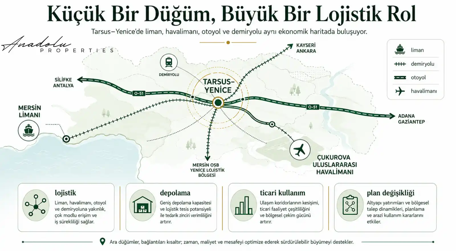
From a real-estate perspective, it is therefore not sufficient to look only at residential prices in Mersin. Port connections, the free zone, logistics and warehousing areas, the Tarsus–Yenice axis, motorway links, industrial uses, and rail freight access may become more meaningful indicators.
The critical point is that an increase in port capacity alone will not automatically raise property values in a specific area. For an effect to emerge, transport volumes, industrial demand, planning decisions, infrastructure investment, and private-sector investment must reinforce one another within the same geography.
TARSUS–YENICE: SMALL ON THE MAP, CRITICAL IN LOGISTICS
In major infrastructure projects, investor attention often focuses on the names of large cities. Yet in corridor economies, the most critical locations can emerge at junctions where different modes of transport and production areas converge.
Tarsus and especially the area around Yenice should therefore be examined separately. In this geography between Mersin and Adana, rail, motorway, port access, and connections to Çukurova International Airport come into close proximity.
As part of the project, an approximately 10-kilometer rail connection to Çukurova International Airport has been planned; official statements at the beginning of 2026 indicated that physical progress on this connection had reached around 90%. In the future, this integration may strengthen the region’s accessibility not only for passenger movement but also for trade, services, warehousing, and logistics functions.
For investors, the first data point to monitor here is not land price. New junctions, connecting roads, logistics investments, plan amendments, commercial-use decisions, and rail access may generate earlier and more meaningful signals.
ADANA: A MAJOR CENTER WHERE PRODUCTION AND LOGISTICS INTERSECT
Adana is not merely one of the corridor’s largest cities by population. It is a strong production center where agriculture, food processing, textiles, machinery, chemicals, energy, and various manufacturing sectors coexist within the same economic geography.
Proximity to Mersin Port already provides Adana with a significant logistics advantage. Strengthening rail capacity and line standards may add a new layer to this advantage in terms of production and foreign-trade connections.
Adana’s western and eastern industrial axes, organized industrial zones, main road connections, rail freight access, and Çukurova International Airport should therefore be assessed together. Future economic activity may not be concentrated entirely in the city center; different commercial real-estate needs may emerge along peripheral axes where production facilities, warehouses, and major transport networks intersect.
CEYHAN: WHERE ENERGY, INDUSTRY, AND RAILWAY MEET ON THE SAME MAP
Ceyhan is one of the micro-regions along the corridor that should be monitored closely. Viewing Ceyhan merely as a district of Adana may understate the area’s energy, industrial, and logistics functions.
Ceyhan has long held a strategic economic position due to its energy infrastructure, industrial uses, road connections, and access to the Mediterranean. Stronger rail infrastructure may add a new transport layer to these existing functions.
Industrial investments, energy projects, warehousing areas, logistics facilities, rail sidings, and planning decisions around Ceyhan should therefore be monitored together. The early investment signal here may appear in industrial and logistics real estate before the residential market; however, this possibility must be verified against current zoning, ownership, infrastructure, and demand data.
OSMANIYE–TOPRAKKALE: A TRANSIT AND DISTRIBUTION AREA BETWEEN TWO PRODUCTION GEOGRAPHIES
Osmaniye is one of the parts of the corridor that investors may overlook, yet it holds strategic importance because of its logistics position. Assessing the city solely by the scale of its own economy would be insufficient.
Osmaniye lies in a transition zone between Çukurova and the Gaziantep–Kahramanmaraş industrial belt. Toprakkale, meanwhile, stands out as one of the key nodes in this transition because of its road and rail connections. According to the Ministry of Transport and Infrastructure’s statement dated 8 February 2026, the 17-kilometer section between Toprakkale and Mamure has been completed.
In this context, the growth directions of organized industrial zones in Osmaniye and Toprakkale, industrial areas close to main transport routes, warehouse investments, new production facilities, and energy–logistics connections should be monitored closely. The region’s potential advantage may derive not only from its own production capacity but also from its position between different production basins.
BAHÇE–NURDAĞI: THE ECONOMIC MEANING OF A GEOGRAPHIC THRESHOLD MAY CHANGE
The Bahçe–Nurdağı crossing is one of the most challenging sections of the Mersin–Gaziantep corridor from an engineering standpoint. Yet precisely for this reason, its economic significance is substantial.
For many years, the mountainous terrain created a natural threshold that affected transport times and costs between Çukurova and Gaziantep. New rail infrastructure crossing this threshold at a higher standard may strengthen the connection between the two economic regions.
Nurdağı’s importance may not be limited to this role. The Ministry of Transport and Infrastructure has stated that project work is continuing on an approximately 49-kilometer high-speed rail connection planned from Nurdağı to Kahramanmaraş, and that the line is intended to be linked in the future with the planned Malatya–Narlı–Nurdağı high-speed rail project.
Nurdağı could therefore become not merely a transit point on the Mersin–Gaziantep line, but a node where different rail corridors may intersect. This is not yet a completed economic reality; it is a strong infrastructure signal that should be monitored closely.
GAZIANTEP: A NEW EQUATION FROM FACTORY TO PORT
At the eastern end of the corridor lies one of Türkiye’s strongest production and export centers: Gaziantep.
For Gaziantep, the most important impact of the Mersin–Adana–Osmaniye–Gaziantep line may be less about passenger transport and more about strengthening the relationship between factory and port. The Ministry of Transport and Infrastructure has explicitly stated that the project is intended to help Gaziantep’s industrial output reach global markets more quickly via Mersin Port.
This should be monitored not only in relation to existing industrial zones but also future industrial expansion areas. Expansion of organized industrial zones, new production investments, logistics centers, warehousing areas, rail freight connections, and access to main roads should be assessed on the same map.
In an export-oriented industrial city, a lasting change in logistics costs and transit times may also affect the nature of real-estate demand over time. However, the extent to which this occurs in any district or micro-region cannot be derived automatically from the infrastructure project; field conditions, planning, and market data must be analyzed separately.
THE INVESTOR’S REAL MAP: NODES WHERE INFRASTRUCTURE LAYERS INTERSECT
From Anadolu Properties’ perspective, the most important figure for investors along this corridor is not 2 hours 15 minutes, but the targeted annual freight capacity of 37.1 million tons. Freight movement is one of the fundamental factors influencing where factories are established, at which junctions warehouses are located, where logistics centers may concentrate, and in which directions demand for industrial land may develop.
It is therefore necessary to move beyond the conventional “station vicinity” approach. The equation to look for is: port + railway + motorway + organized industrial zone + airport + production + warehousing + exports.
Areas where these layers begin to overlap within the same geography should be examined more closely as potential future economic nodes. Yet intersection alone is not sufficient for an investment decision; zoning, ownership, infrastructure capacity, actual demand, accessibility, environmental conditions, and price levels must also be verified.
- Mersin–Tarsus–Yenice: A logistics gateway where the port, free zone, railway, motorway, and airport connections intersect.
- Adana–Ceyhan: A central corridor where production, agriculture, energy, industry, and logistics functions converge.
- Osmaniye–Toprakkale: A transit and distribution area linking the production basins of Çukurova and Southeastern Anatolia.
- Bahçe–Nurdağı: A rail node whose strategic importance may increase as the geographic transport threshold is overcome and a potential Kahramanmaraş connection is added.
- Gaziantep: An eastern production center where production and export capacity may establish stronger links with Mediterranean ports.
THE CORRIDOR MAY NOT END IN MERSIN AND GAZIANTEP
What truly differentiates this line is its planned integration with larger logistics corridors. According to the Ministry of Transport and Infrastructure’s statement dated 26 May 2026, the Mersin–Adana–Osmaniye–Gaziantep High-Speed Rail Project is planned to be integrated with the Development Road via the high-speed rail line intended to extend from Gaziantep to Ovaköy, and with the Middle Corridor via the Aksaray–Ulukışla–Yenice High-Speed Railway Project.
If this integration is realized, the line we currently assess between Mersin and Gaziantep could become part of a broader economic system linking Mediterranean ports with the production centers of Southeastern Anatolia, the direction of Iraq and the Persian Gulf to the east, the Middle Corridor to the north, and European markets to the west.
For Turkish investors living in Europe and investors evaluating commercial real estate in Türkiye remotely, this is precisely the point that matters: instead of converting an infrastructure headline directly into a price expectation, the focus should be on how the project intersects with production, exports, logistics, and planning decisions.
EARLY-WARNING SYSTEM: WHICH DATA SHOULD BE MONITORED BEFORE PRICES?
The generalization that “land along the line will appreciate” is both incomplete and speculative. A more robust approach is to monitor the indicators in which economic transformation appears before it is reflected in prices.
First, examine where freight is moving, and then where factories are expanding. Next, assess organized industrial zone boundaries, new junctions, rail freight connections, logistics centers, warehouse investments, plan amendments, employment movements, and population dynamics. Price is often not the beginning of economic transformation, but its outcome.
- Infrastructure signal: The presence of only a new railway or road investment in an area.
- Strengthening economic signal: The railway intersects with an organized industrial zone, production area, or logistics center.
- Multimodal transport signal: Motorway, port, airport, or new junction investments are added to the railway connection.
- Transformation signal: New industrial investment, plan amendments, employment growth, and private-sector logistics investments appear together within the same micro-geography.
- Investment-decision stage: These signals are verified against current zoning, title deed, ownership, valuation, field, and market data.
READING THE MAP OF THE FUTURE: FOLLOW THE FREIGHT FIRST
The Mersin–Adana–Osmaniye–Gaziantep High-Speed Railway Line matters for investors because it aims to connect one of Türkiye’s strong production regions with a major foreign-trade gateway through a higher-capacity rail system.
If the project’s impact is sought only in passenger transport or the residential market around stations, the broader picture may be missed. The real transformation may emerge in how the economic relationship changes among Mersin Port, Tarsus–Yenice, Çukurova Airport, Adana’s production areas, Ceyhan, Osmaniye–Toprakkale, Bahçe–Nurdağı, and Gaziantep’s industrial zones.
In the coming years, assessment of this corridor should not be limited to the progress rate of high-speed rail construction. Expansion of organized industrial zones, logistics centers, rail freight connections, port capacity, new motorways and junctions, industrial investments, plan amendments, employment, and population movements should be evaluated within the same data set.
In major infrastructure investments, the most valuable question for an investor is not “Where will the train pass?” The real question is: “As the targeted 37.1 million tons of freight movement comes online, at which nodes will production, logistics, and capital begin to concentrate?”
To understand the real-estate map of the future, the first task is not to read the buildings, but to read the direction in which freight, production, and capital are moving.
Mustafa Yılmaz
CEO – Anadolu Properties
Europe – Türkiye Investment Bridge