THE NEW MAP OF REAL ESTATE INVESTMENT IN TÜRKİYE: 10 INVESTMENT CORRIDORS FOCUSED ON ENERGY, DATA AND LOGISTICS | RESEARCH SERIES 02
Reading Türkiye’s Next 10 Years Through Corridors, Not Cities
The most notable real estate and land investment stories of the next decade in Türkiye do not necessarily have to emerge in the areas with the highest square-meter prices today.
The real transformation may take place in corridors where energy capacity is strengthened, railways arrive, organized industrial zones expand, access to ports becomes shorter, data infrastructure becomes denser, and production shifts into new areas.
As of June 2026, Türkiye has 419 organized industrial zones in total: 373 OIZs affiliated with the Ministry of Industry and Technology and 46 Agriculture-Based Specialized Organized Industrial Zones affiliated with the Ministry of Agriculture and Forestry. The Ministry of Industry and Technology also publishes the geographical distribution of OIZ projects included in the 2026 Investment Program. This data is important not only for understanding where industry is located today, but also for reading the areas toward which public infrastructure is expanding.
A new scale is also emerging in technology infrastructure. As part of its strategic cooperation with Google Cloud, Turkcell announced plans to invest USD 1 billion in data centers and cloud technologies by the end of 2032. Investments of this kind show that data centers have become a new asset class generating physical real estate demand through energy capacity, fiber access, large-site requirements, and secure infrastructure—not only for the technology sector.
On the railway side, the Ministry of Transport and Infrastructure aims to expand the network, stated at 13,919 kilometers in 2025, to 17,500 kilometers by 2028 and 28,600 kilometers by 2053. During the same period, strengthening rail siding connections to OIZs, ports, and logistics centers is also an important component of transport policy.
When these developments are placed on the same map rather than read separately, a more critical question emerges:
In which corridors will Türkiye’s future flows of production, energy, data, and logistics intersect?
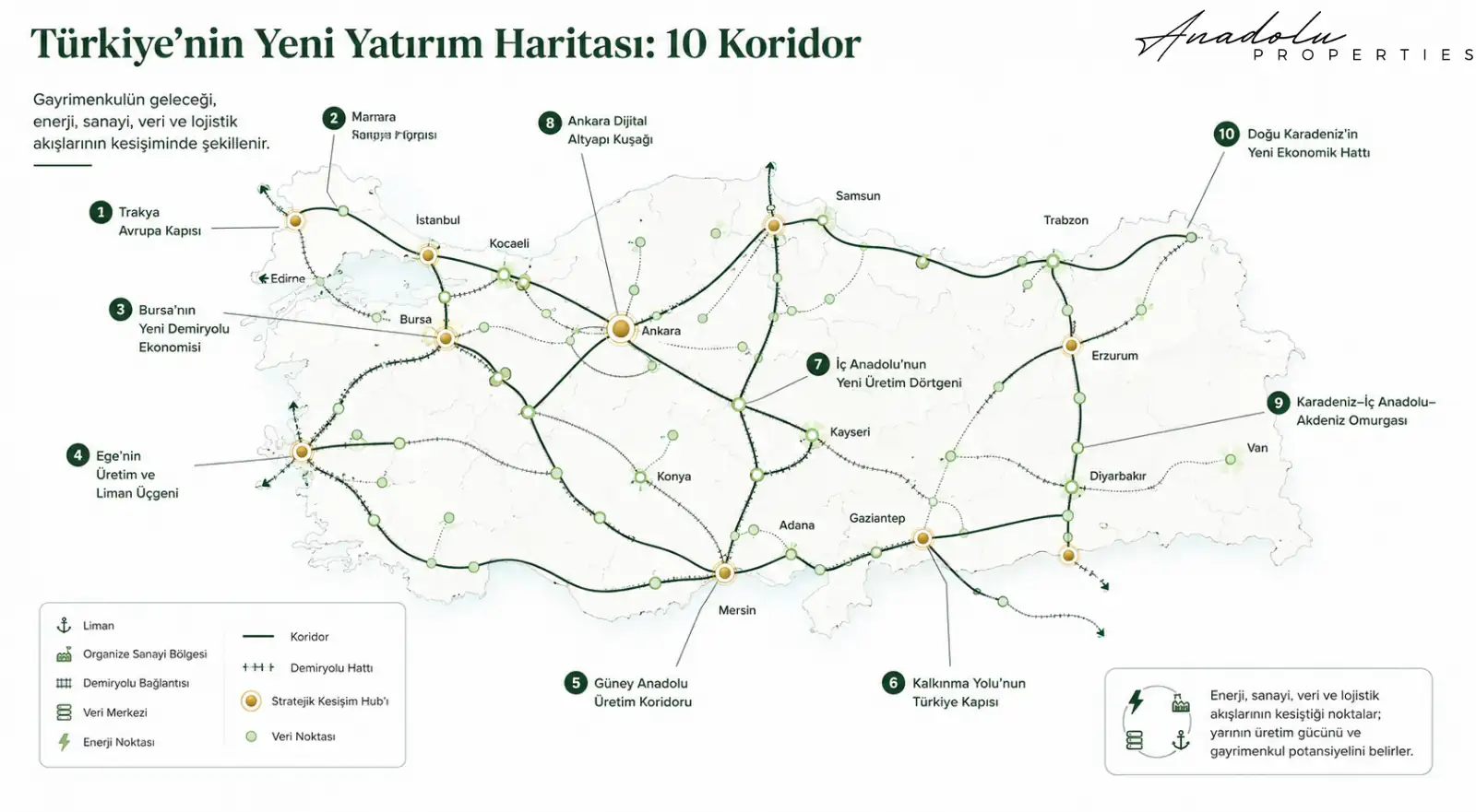
At Anadolu Properties, we approach Türkiye in this study not through lists of cities, but through economic corridors and points of intersection. Within this framework, we assess 10 axes that we believe warrant close monitoring over the next 3–10 years.
1. Thrace Gateway to Europe: Halkalı – Çatalca – Çerkezköy – Kapaklı – Edirne – Kapıkule
One of Türkiye’s most critical road and rail corridors opening toward Europe is entering a new phase.
While work continues on the Çerkezköy–Kapıkule section of the Halkalı–Kapıkule Railway Project, the first reciprocal, one-off freight train operation was carried out on the line on June 17, 2026. This development is significant not only for testing and operational readiness, but also as an indicator of the logistics role of this axis connecting Türkiye to the European rail network.
Looking at this area merely as “a new railway is coming” would be insufficient. In the same geography:
- Istanbul’s westward expansion,
- the Çerkezköy–Kapaklı industrial cluster,
- road and rail access to the European market,
- increasing freight capacity,
- planned industrial areas in Thrace
are converging within the same economic corridor.
Which areas should be monitored at the micro level?
Çatalca’s logistics connections, the surroundings of Çerkezköy OIZ, the Kapaklı industrial belt, the Velimeşe–Ergene axis, the Lüleburgaz area, and the Edirne–Kapıkule logistics axis are nodes in this corridor that deserve more detailed analysis.
The early signal here is not residential demand alone. The key combination to monitor is industrial land + warehousing + logistics + energy capacity + transport connectivity.
For this reason, in some parts of Thrace, long-term value creation may come less from housing spilling over from Istanbul and more from the production and logistics economy serving Europe. However, it should not be assumed that the industrial story will affect every parcel equally.
2. Marmara Industrial Backbone: Gebze – Izmit – Sakarya – Bilecik – Bozüyük – Eskişehir
One of Türkiye’s strongest production regions should be viewed as a single economic backbone extending from Istanbul toward central Anatolia.
Gebze and Kocaeli are already strong in industry, ports, logistics, automotive, chemicals, technology, and access to a large consumer market. For investment analysis, however, the main question is not which centers are strong today, but along which routes this production capacity is expanding into Anatolia.
The corridor extending through Sakarya–Bilecik–Bozüyük to Eskişehir is therefore strategic.
An important logistics signal emerged in Eskişehir on May 30, 2025, when the foundation was laid for the Eskişehir OIZ–Hasanbey Logistics Center rail connection. The 14-kilometer link is intended to connect high-tonnage products manufactured in the OIZ more directly by rail to ports and other logistics centers.
Micro belt to monitor
Gebze–Dilovası, Kartepe–Arslanbey, Sakarya industrial areas, Osmaneli, Bilecik, Bozüyük, İnönü, Eskişehir OIZ, and the surroundings of Hasanbey Logistics Center.
Industrial–rail–road intersections should be monitored particularly closely here. Production investments moving out of Istanbul or seeking new capacity do not look only for inexpensive land.
They look for energy + transport + labor + a supplier network.
Anatolian corridors that can provide these four criteria together may become more visible in new industrial and commercial real estate demand in the coming years.
3. Bursa’s New Railway Economy: Osmaneli – Yenişehir – Bursa – Karacabey – Bandırma
Bursa is already one of Türkiye’s most important industrial centers. However, one of the city’s structural limitations has been the insufficient integration of its high production capacity with the main railway network.
The Bandırma–Bursa–Yenişehir–Osmaneli line has the potential to change this equation.
Rather than focusing only on central Bursa, the map should be read from east to west:
Osmaneli → Yenişehir → Bursa → Karacabey → Bandırma
At the eastern end of this chain lies the Anatolian railway system, at its center Bursa’s production capacity, and at the western end Bandırma and the Sea of Marmara.
Accordingly, along this line in the future:
- logistics centers,
- warehouses,
- supplier industries,
- production facilities,
- commercial areas,
- housing demand linked to the working population
may reinforce one another across different real estate categories.
Areas for early monitoring
The surroundings of Yenişehir, Bursa’s eastern industrial belt, production areas extending westward from Nilüfer, Karacabey, and the inland parts of Bandırma merit more detailed location analysis.
The core investment question here should not be “Where does the train pass?” but “At what point does industry connect to the railway?”
Because the real estate effect is usually created not by the existence of the line itself, but by the line’s actual connection with production and logistics functions.
4. The Aegean Production and Port Triangle: Manisa – Kemalpaşa – Aliağa – Izmir
The Aegean may be one of the production geographies that deserves close attention in the coming period. Yet viewing Izmir only through housing and tourism risks overlooking the region’s industrial and logistics transformation.
The main economic triangle is forming between Manisa – Kemalpaşa – Aliağa.
Manisa is a strong production center. Kemalpaşa is Izmir’s eastern industrial and logistics gateway. Aliağa is a distinctive hub where ports, petrochemicals, energy, heavy industry, and maritime transport converge.
The industrial zones around Kemalpaşa Logistics Center and their port connections add another layer that strengthens this triangle. As these areas become more strongly connected, Izmir’s northern and eastern hinterland may cease to be merely “land outside the city” and become part of the production and logistics geography.
Micro belts to monitor
Menemen, Aliağa, the surroundings of Manisa OIZ, Muradiye, Kemalpaşa, and Torbalı’s industrial connections.
There is, however, a critical distinction: not every field is part of this story.
Planning decisions, transport connections, energy infrastructure, the direction of industrial expansion, and land-use status must be examined at parcel level. Agricultural land, protection designations, and zoning decisions in particular can completely alter the macro investment thesis.
5. Southern Anatolia Production Corridor: Mersin – Tarsus – Adana – Osmaniye – Gaziantep
The Mersin–Gaziantep axis may be one of Türkiye’s strongest candidates for an economic corridor over the next decade.
Because the same line brings together:
- Mersin Port,
- the logistics connections of Tarsus and Yenice,
- Adana’s production strength,
- the Ceyhan energy zone,
- Osmaniye’s industry,
- Gaziantep’s export capacity
within a single corridor.
The Ministry of Transport and Infrastructure continues to list the approximately 312-kilometer Mersin–Adana–Osmaniye–Gaziantep high-speed railway among its strategic projects. At the end of 2024, the Ministry stated that it targeted completion in 2026; statements issued in 2026, however, indicate that work is continuing and that the project is intended to connect Mersin’s ports more strongly with Gaziantep and beyond.
This distinction matters: a target date is not the same as a completed project. Investors should track current physical progress rather than the project headline.
Here, the significance of rail goes far beyond passenger transport. If the time and logistics cost of moving goods produced in Gaziantep to Mersin Port changes, the economics of production location can change as well.
Belt to monitor
Mersin’s port hinterland, Tarsus, Yenice, the surroundings of Adana OIZ, Ceyhan, Toprakkale, Osmaniye OIZ, and Gaziantep OIZ connections.
Within this corridor, areas where rail junctions intersect with OIZ connections should be monitored especially closely. Demand may grow not only for housing, but also for industrial land, warehouses, commercial facilities, and logistics real estate.
6. Türkiye Gateway of the Development Road: Gaziantep – Şanlıurfa – Mardin – Ovaköy
This corridor has a longer-term horizon; however, to the extent that it materializes, its impact could be significantly larger.
The Development Road, planned to extend from the Persian Gulf through Iraq into Türkiye and onward to Europe, could reshape the economic geography of southeastern Türkiye as it progresses.
The core issue here is not merely a new transit route. Over time, international trade corridors can generate numerous economic functions around them, including:
- logistics centers,
- warehouses,
- truck parks,
- customs clearance services,
- maintenance and service areas,
- production,
- packaging,
- distribution,
- new commercial centers
and many other economic functions.
Broad corridor to monitor
Gaziantep, Şanlıurfa, Mardin, the Nusaybin area, Şırnak, and Ovaköy.
For investors, however, the most important word here is timing.
The Development Road is a long-term, multi-stakeholder project. Project announcements should therefore not be priced as if economic value has already materialized; the route, financing, tenders, expropriation, border and customs infrastructure, and construction progress should be monitored step by step.
The potential may be high. So is the uncertainty. This corridor is a good example of why risk control is indispensable when translating a macro narrative into a micro-level investment decision.
7. Central Anatolia’s New Production Quadrilateral: Ankara – Eskişehir – Konya – Kayseri
Reading Türkiye’s industrial geography solely through Marmara may increasingly become an incomplete approach.
Four major centers stand out in Central Anatolia:
Ankara: defense industry, technology, public investment, and advanced engineering.
Eskişehir: aerospace, rail systems, machinery, and advanced industry.
Konya: machinery, automotive supply industry, and broad production infrastructure.
Kayseri: furniture, machinery, metalworking, and an export-oriented industrial structure.
As the transport and logistics connections among these four centers strengthen, a Central Anatolian production network may emerge rather than a set of isolated cities.
Kayseri’s connection to the high-speed rail network via Yerköy, the connection of Eskişehir OIZ to Hasanbey Logistics Center, and Ankara’s weight in technology and data infrastructure should be read as different parts of the same larger picture.
What should be sought from a land perspective?
- directions of OIZ expansion,
- connections to logistics centers,
- ring roads and major junctions,
- rail freight loading points and siding connections,
- industrial areas with access to high energy capacity,
- parcels suitable for large-scale production.
One potential advantage of this quadrilateral is that some areas may offer broader development space than Marmara. But abundant land supply is not an investment thesis in itself; actual access to infrastructure is decisive.
8. Ankara Digital Infrastructure Belt: Ankara – Gölbaşı – Temelli – Polatlı
This corridor is different from the others. The main story here is not the port.
Data + defense + technology + energy + public infrastructure.
Beyond being Türkiye’s political center, Ankara is also a concentration point for defense industry, satellite technologies, telecommunications, public data infrastructure, universities, and advanced-technology companies.
According to Ministry of Industry and Technology data, as of July 1, 2026, Türkiye had 1,368 R&D centers, 345 design centers, and 114 technology development zones. This picture shows that the physical geography of the technology economy is also expanding.
From a real estate perspective, a category different from conventional residential land needs to be considered here: land suitable for digital infrastructure.
The criteria for such locations are different:
- high energy capacity,
- fiber access,
- backup power capability,
- security,
- large and functional parcels,
- connection to main transport networks,
- appropriate planning and land-use designation,
- the ability to meet cooling and technical infrastructure requirements.
Broad axis to monitor
Gölbaşı, southwestern Ankara, Temelli, the surroundings of Başkent OIZ, and the direction toward Polatlı.
The point requiring particular caution here is this: rather than buying land on the assumption that “a data center may come,” investors should analyze whether the location actually meets data-center siting criteria.
The absence of even one of the required energy, fiber, or planning conditions can weaken the investment thesis.
9. Black Sea–Central Anatolia–Mediterranean Backbone: Samsun – Çorum – Kırıkkale – Ankara and the Southern Connection
This north–south backbone is one of Türkiye’s relatively less discussed but strategically noteworthy corridors.
Work is continuing on the 120-kilometer Delice–Çorum section, the first stage of the Ankara–Kırıkkale–Çorum–Samsun high-speed railway. As of June 5, 2026, the Ministry of Transport and Infrastructure stated that overall progress on this section had exceeded 25 percent and that tenders had also been completed for the Çorum–Merzifon and Merzifon–Havza sections.
More important is how the Ministry defines the project. Once completed, the line is expected to carry 12 million passengers and 14 million tons of freight annually and to form part of a broader north–south corridor linking Samsun Port with Mersin Port.
This would represent an important change in Türkiye’s economic geography. While the country’s main production and logistics map is often conceived along an east–west axis, a new:
Black Sea → Central Anatolia → Mediterranean
backbone could emerge.
Early-signal areas
The Samsun hinterland, Havza, Merzifon, Çorum, Delice, and Kırıkkale.
Çorum in particular is becoming a center that deserves closer monitoring on this map. Connecting an Anatolian city with a strong production tradition to a new high-capacity rail corridor may affect industrial site selection and demand for warehousing and logistics over the long term.
However, proximity to a station or line is not sufficient on its own. OIZ connectivity, ring-road access, energy infrastructure, and planning decisions must be assessed together.
10. The Eastern Black Sea’s New Economic Line: Samsun – Ordu – Giresun – Trabzon – Rize – Sarp
This corridor is at an earlier stage than the other nine. It is therefore one of those that should be read with the greatest caution.
The Ministry of Transport and Infrastructure states that project and feasibility studies are continuing for the Samsun–Trabzon–Sarp high-speed railway. In a February 2026 statement, the objective was described as connecting Ordu, Giresun, Trabzon, Rize, and Artvin from Samsun onward. Under the previously announced project framework, the line is planned to be approximately 509 kilometers long and to serve both passenger and freight transport.
If realized, this could add a new railway layer to the Eastern Black Sea economy, which today operates largely along a linear road corridor.
Land investors, however, need to be especially cautious here. The Black Sea region is one of Türkiye’s most complex geographies in terms of:
- topography,
- landslide risk,
- agricultural land,
- coastal restrictions,
- expropriation,
- zoning,
- buildable land
and related development constraints.
Accordingly, opportunity analysis here should be conducted not at province level but almost at parcel level. A macro project narrative should not be turned into an investment thesis before topography and legal land-use conditions are verified.
What Do We See When We Overlay the 10 Corridors?
When we step back from the map, the most important conclusion becomes visible.
Although Türkiye’s major infrastructure projects may appear independent of one another, some cities and regions are beginning to sit at the intersection of multiple systems.
Eskişehir: Industry + railway + logistics + access to Ankara/Istanbul.
Samsun: Port + Central Anatolian railway + potential future Eastern Black Sea connection.
Mersin: Port + southern industrial corridor + north–south freight connection.
Gaziantep: Industry + exports + Mersin connection + Development Road potential.
Ankara: Technology + data + defense + railway centrality.
Bursa: Industry + new railway connection + Marmara logistics system.
Manisa–Izmir: Industry + port + energy + exports.
These are not a “list of cities where land should be bought.”
They are nodes that warrant deeper analysis.
From an investment perspective, the core value often comes not from a city’s general story, but from the micro-location where energy, transport, production, logistics, and planning data intersect within that story.
You Do Not Buy a City; You Buy an Intersection
The investment logic of the future requires an important shift in mindset.
An investor should not ask only, “Will Eskişehir develop?”
They should ask:
- In which direction is industry expanding in Eskişehir?
- Where does the railway connect to industry?
- Where are new ring roads and logistics connections emerging?
- In which areas is energy capacity stronger?
- What is the actual accessibility between the logistics center and the production area?
- Which neighborhoods, blocks, and parcels lie at the intersection of these investments?
The same approach applies to Bursa, Mersin, Gaziantep, Samsun, Izmir, and Ankara.
Because a city is not what is purchased. A location is.
And a good location often means not merely being close to a single project, but being positioned at the intersection of multiple economic flows while also having the right legal and technical conditions.
Anadolu Properties Early Warning Model: Reading Eight Layers Together
We believe that eight fundamental layers should be assessed together when measuring the real estate investment potential of a region in Türkiye in the coming period.
1. Energy Layer
Substations, high-voltage infrastructure, generation capacity, new energy investments, and grid access for large consumers.
2. Transport Layer
Motorways, divided roads, railways, ring roads, junctions, and rail siding investments.
3. Logistics Layer
Ports, logistics centers, freight terminals, customs facilities, and intermodal connections.
4. Industry Layer
Existing OIZs, occupancy rates, expansion areas, new OIZ decisions, and production clusters.
5. Data Layer
Fiber infrastructure, data centers, technology development zones, telecommunications infrastructure, and high-capacity digital connections.
6. Public Investment Layer
Expropriations, investment programs, hospitals, universities, public facilities, mass housing, and major infrastructure projects.
7. Demographics Layer
Migration, population, number of employees, income, employment structure, and housing needs.
8. Parcel Layer
Zoning, ownership, road frontage, parcel geometry, topography, agricultural status, protected areas, and development conditions.
No single layer is sufficient on its own to support an investment decision.
However, when five or six layers begin to overlap at the same point, that area may become an “early warning zone” that warrants more detailed investigation.
The objective is not to declare future price appreciation in advance, but to determine systematically which locations deserve more data collection before an investment decision is made.
A Project Announcement and an Investment Opportunity Are Not the Same Thing
This distinction is especially important.
The passage of a high-speed rail line through an area does not mean that all land in that area will appreciate.
The establishment of an OIZ does not mean that all surrounding fields will become industrial land.
The announcement of a data center investment does not turn every nearby parcel into data-center land.
Even a motorway junction does not always create value.
In some cases:
- expropriation,
- agricultural protection status,
- protected-site designation,
- water-basin restrictions,
- controlled-access transport areas,
- zoning restrictions,
- geological problems,
- unsuitable parcel geometry,
- lack of access or infrastructure
can completely undermine the investment thesis.
Therefore, when moving from a macro narrative to a micro-level investment, analysis must descend to the level of:
city → district → neighborhood → block → parcel
without exception.
Especially in land and field investments, relying only on a project announcement without jointly checking zoning status, ownership, official planning decisions, road access, topography, and valuation data can create serious risk.
What Could Be the Truly Scarce Resource in Türkiye Over the Next 10 Years?
When we adapt the “scarcity” framework highlighted in BlackRock Investment Institute’s 2026 investment outlook to Türkiye’s real estate map, a striking conclusion emerges.
The scarce resource of the future may not be land alone.
Land connected to infrastructure may be scarce.
Land with access to electricity.
Land that can connect to rail.
Land within a port hinterland.
Land into which an OIZ can expand.
Land with fiber access.
Land suitable for large-scale production.
Land that can connect functionally to major transport axes.
The supply of such land is not unlimited. As artificial intelligence and data-center investments increase demand for energy and infrastructure, supply chains are reconfigured, and new production capacity is planned together with logistics networks, infrastructure access may become even more critical.
For this reason, even two adjacent parcels can have major economic differences.
One may have only land.
The other may have access to energy, data, production, and logistics.
Reading the Real Estate Map of the Future Correctly
The next decade in Türkiye may not simply be a period in which new roads, factories, data centers, or railways are built. More importantly, it may be a period in which these infrastructures become connected to one another.
Thrace is connecting to Europe, Bursa to rail, Eskişehir to the logistics system, Gaziantep to Mersin, Samsun to Central Anatolia, the Eastern Black Sea to the national railway network, and Ankara increasingly to the digital economy.
For this reason, viewing the map of Türkiye only through city boundaries may no longer be sufficient for investors.
The new map is made up of:
- energy lines,
- railways,
- OIZ expansions,
- port hinterlands,
- data-center and fiber infrastructure,
- logistics corridors
and the connections among them.
The fundamental question of real estate research changes here as well.
Not: Where is expensive today?
Nor: Where is cheap today?
The real question is:
In which direction will Türkiye’s capital, energy, production, and logistics move over the next 3–10 years?
And immediately after that comes the more difficult question:
Before this movement is fully reflected in prices, in which districts, neighborhoods, and parcels might these forces begin to intersect?
The future of real estate intelligence lies precisely here: following movement rather than price; seeing the signal rather than the outcome; analyzing the corridor rather than the city, the intersection rather than the corridor, and ultimately the intersection at parcel level.
This study has been prepared for general information and regional analysis purposes. The corridors identified here do not constitute a guarantee that any property will appreciate in value or a recommendation to buy or sell. Project schedules, routes, planning decisions, and investment programs may change. Real estate decisions should be assessed on an asset-by-asset basis through legal, technical, zoning, and market due diligence.
Mustafa Yılmaz
CEO – Anadolu Properties
Europe – Türkiye Investment Bridge