The Investment Map of the Future | #08 A NEW INDUSTRIAL MAP COVERING 59,000 HECTARES
19 Areas Along the Samsun–Mersin Corridor: When Does Planning Become Actual Use?
When a new industrial area is announced, the property discussion quickly turns to prices. Yet the first question that should underpin an investment decision is more concrete: Which part of the announced area can be opened for production, under what conditions and when?
In his address at the “New Focus of Investment: Creating Value for the Future Summit” on 7 October 2026, Minister of Industry and Technology Mehmet Fatih Kacır stated that, in the first phase, 19 new investment areas totalling 59,000 hectares had been designated across 15 provinces in the Central Anatolian belt formed by the Samsun–Mersin corridor. The same speech set out the target of increasing planned industrial land from 164,000 hectares in 2025 to 350,000 hectares by 2030.
These figures indicate the direction of industrial geography; they do not constitute an inventory of fully serviced plots available for allocation. Creating areas supported by rail, port and road connections, with social amenities and provision for green and smart production, is a planning vision. The implementation timetable for each area needs to be examined separately.
Source: Mehmet Fatih Kacır, summit address, 7 October 2026
From Marmara to Anatolia: The Economic Rationale for Redistribution
Industrial concentration in Marmara creates challenges that need to be considered together: land costs, transport pressure, room for expansion and environmental infrastructure. The Industrial Areas Master Plan should be read as an approach aimed at distributing production more evenly across Anatolia.
Within this framework, the Samsun–Mersin axis highlights the links between production centres, roads, railways and ports. However, the term corridor does not mean that an uninterrupted industrial strip will be built between the two cities or that every agricultural plot along the route will become industrial land.
What Does 59,000 Hectares Tell Us—and What Does It Not?
59,000 hectares equals 590 million square metres or 590 square kilometres. We cannot treat this entire area as factory plots, private property or land available for sale. Roads, energy infrastructure, treatment facilities, logistics, green spaces and social amenities may also be included in the total. In a property assessment, the key is to distinguish the net usable area and the conditions governing its use.
Reading the January and October Announcements Separately
The Southeastern Anatolia Exporters’ Associations’ announcement dated 20 January 2026 refers to 16 new industrial areas across 13 provinces, totalling 59,000 hectares. The October announcement refers to 15 provinces and 19 investment areas with the same total area.
It would be wrong to interpret this difference automatically as an increase in capacity. The announcements we reviewed do not clarify possibilities such as additional areas, boundary changes or differences in the scope of counting. Without the current list of areas, coordinates and official decisions, placing all 19 areas on an investment map with definitive boundaries would be unreliable.
Source: GAİB, 16 new industrial areas across 13 provinces, 20 January 2026
Why Keep Eskişehir Under Review?
Eskişehir is among the 13 provinces listed in the January announcement. Its established industrial base, rail connections and workforce experience make it worth monitoring. Reporting on the Eskişehir Economic Consultation Meeting of 20 August 2026 states that Vice President Cevdet Yılmaz emphasised an integrated production approach incorporating rail connections, employee housing and industrial colleges.
Nevertheless, we cannot assume that every plot in the city falls within the new area. The scope of existing structures such as the Beylikova Agriculture-Based Specialised Organised Industrial Zone and the Sivrihisar Organised Industrial Zone must not be confused with that of the new mega industrial areas. A provincial announcement does not replace a boundary and planning review of a specific property.
Source: Eskişehir.net / İHA, Economic Consultation Meeting, 20 August 2026
The Threshold from Announcement to Plot-Level Implementation
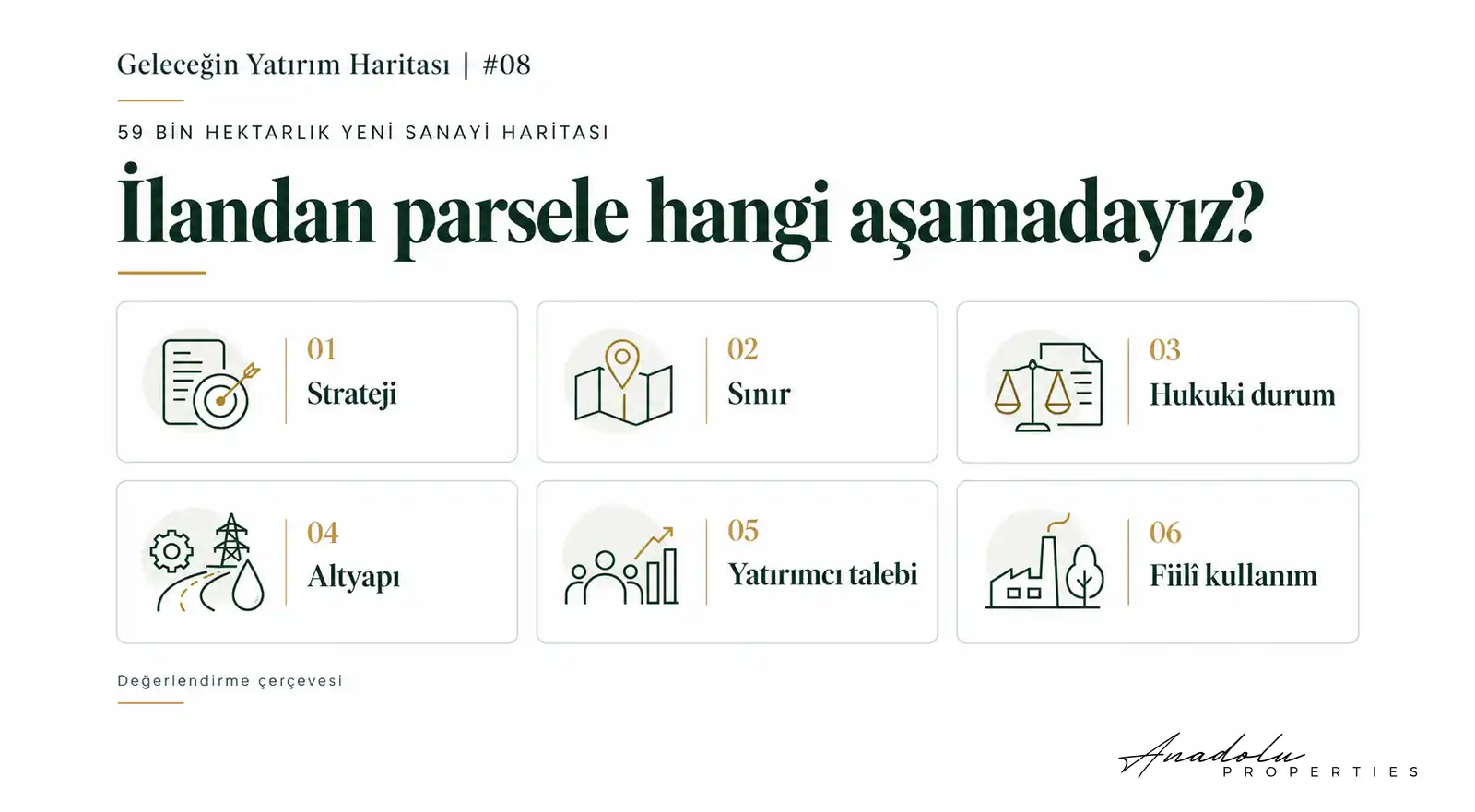
In this article, I use the expression “Threshold from Announcement to Plot-Level Implementation” to assess how a public investment or planning decision translates into a legally implementable, infrastructure-supported and economically usable function on a specific property. This is neither an official document nor a permit procedure that follows an unchanging sequence for every project. The six headings help examine how the decision is taking shape on the ground.
1. Strategic Planning
Announcing a corridor or investment area indicates the direction of public policy. It does not, by itself, confer development rights on a plot. The scope of the announcement, the competent authorities and the decisions on which it rests should be identified.
2. Definitive Spatial Boundaries
Province and district names are starting points. A property cannot be said to lie within a project until its boundaries have been verified at neighbourhood, coordinate, cadastral block and plot level. An approximate promotional map is not evidence of property boundaries.
3. Legal Status and Planning
Environmental plans, master zoning plans and implementation zoning plans should be examined alongside title records, expropriation and the opinions of the relevant authorities. Special conditions affecting agricultural land, pastures, forests or protected areas require separate assessment. The procedures for non-agricultural use under Law No. 5403 do not disappear with a corridor announcement.
The current regulation concerning agricultural land is titled the “Regulation on the Protection and Use of Agricultural Land”, published on 4 April 2026. The provisions and permits applicable to a particular plot must be verified against legislation in force and the records of the competent authorities.
Source: Ministry of Agriculture and Forestry, announcement of the new regulation, 6 April 2026
4. Technical Infrastructure
Electrical capacity, water supply, wastewater and treatment, natural gas, road and rail access, communications and fire safety should be examined against production requirements. A planned connection does not mean that capacity is available today. Capacity, the completion timetable and connection conditions should be investigated together.
5. Investor and Production Demand
Which sectors and companies have actually decided to invest? What stage have allocation, permitting and construction reached? Setting aside a large area does not create occupancy on its own. Workforce, supply chains, energy, logistics, financing and market access conditions influence investor demand.
6. Actual Economic Use
Factories beginning operations, employment, production and shipments turn demand for storage and services into something tangible. Changes in surrounding uses and completed rental and sale transactions help assess how expectations are being reflected on the ground. Asking prices are not the same data as these transactions.
Two Plots in the Same Corridor, Different Uncertainties
Consider two properties close to each other. Let the first be agricultural land said to lie within the corridor, but whose official boundary has not been verified. Let the second have a verified industrial land-use plan, connection conditions and allocation terms.
Comparing these properties solely by location or price per square metre would be incomplete. The first carries uncertainty over a change of use and inclusion in the project; for the second, the implementation timetable, costs and demand still require separate examination. This illustrative example does not imply that the first property will necessarily gain development permission or that the second will deliver a return.
How Does Demand Develop Around an Integrated Industrial Area?
An integrated industrial settlement consists of more than factories. Storage, technical services, employee housing, education and everyday commercial needs may also arise. However, the scale of these functions depends on the companies and sectors locating there, the number of employees and the relationship with existing settlements.
Automatic demand for housing or commercial space in the surrounding area should not be assumed before a link is established between production, employment and actual user needs. There is also a gap in timing and implementation between including social amenities in a plan and bringing them into use.
Risks That the Size of an Area Cannot Conceal
Water and energy capacity are decisive, particularly in resource-intensive sectors. Agricultural land protection and ownership issues may affect implementation. Extended infrastructure timetables, financing costs and changing sector conditions can also alter the initial assumptions.
For this reason, a “large area” and “strong demand” are not the same thing. Producers must be able to operate here, sustain their operations and access their markets. The economic value of industrial property depends on these conditions coming together.
Eight Indicators to Monitor Before an Investment Decision
- The current official list and coordinates of the 19 areas.
- Official information explaining the difference between the 16 areas in January and the 19 in October.
- Planning approvals and the scope of plan amendments.
- Title, expropriation and land-use conditions.
- The capacity and timetable of electricity, water, wastewater and transport investments.
- Allocations, factory permits and actual construction progress.
- Production, employment and shipments that have begun.
- Changes in surrounding uses and completed rental and sale transactions.
Track Implementation to Understand Value
Anadolu Properties’ approach is to read public announcements alongside verification at plot level. A property should not be judged solely on regional developments before its boundaries, legal status, infrastructure and actual investor demand are understood.
The new industrial map covering 59,000 hectares is a significant planning agenda. From a property perspective, the central question is which part will become operational, for what use and when. Tracking implementation is as necessary as monitoring the announced scale.
Before asking “Which plot will appreciate?”, let us ask: “What stage has this area reached in the process of becoming a production location?”
This article provides a general assessment framework. Current official records, technical conditions and legal status must be examined separately for each property; planning announcements do not guarantee appreciation or investment returns.
Mustafa Yılmaz
CEO – Anadolu Properties
Europe–Türkiye Investment Bridge