TÜRKİYE’S NEW AXES | #08: CAN THE DEVELOPMENT ROAD RESHAPE THE ECONOMIC MAP ALONG THE GAZIANTEP–ŞANLIURFA–MARDIN–NUSAYBIN–OVAKÖY CORRIDOR?
Reading the Development Road Only as a Transport Project Would Be Incomplete
When we look at southeastern Türkiye, we often read its cities as separate economic centers. We associate Gaziantep with industry and exports, Şanlıurfa with agriculture and food production, Mardin with tourism and border trade, and Nusaybin with border crossings and railway connectivity.
As the Development Road Project advances, it may become necessary to assess these cities not one by one, but as different nodes within the same production and logistics system. The project’s core approach is to carry a road and railway system northward from Al-Faw Port on Iraq’s Persian Gulf coast, connect it to Türkiye, and then provide access to Europe and different maritime basins through Türkiye’s existing transport networks.
The cooperation framework among Türkiye, Iraq, Qatar and the United Arab Emirates also indicates that the Development Road is not merely a transport investment planned between two countries, but part of an effort to establish an alternative trade and logistics corridor between the Gulf and Europe.
From a real-estate perspective, however, our primary concern is not where the road will pass. For an international corridor to generate regional value, freight must do more than simply pass through: it needs to stop, be stored, transferred, cleared through customs, processed, distributed and connected with production.
When freight arriving from the Persian Gulf enters Türkiye through Ovaköy, which cities in the Southeast could move beyond being transit points and become new economic nodes?
This distinction matters. Transit traffic may simply use road capacity. Economic impact emerges when secondary functions develop, such as logistics centers, warehouses, bonded warehouses, truck parking, customs services, maintenance and servicing, distribution, packaging and, in some areas, new production investments.
Accordingly, when assessing the Development Road’s real-estate impact in the Southeast, the relevant question should not be “Where does the new road pass?” but “At which points does the new freight flow meet new economic activities?”
Each Point Along the Ovaköy–Gaziantep Corridor Has a Different Role
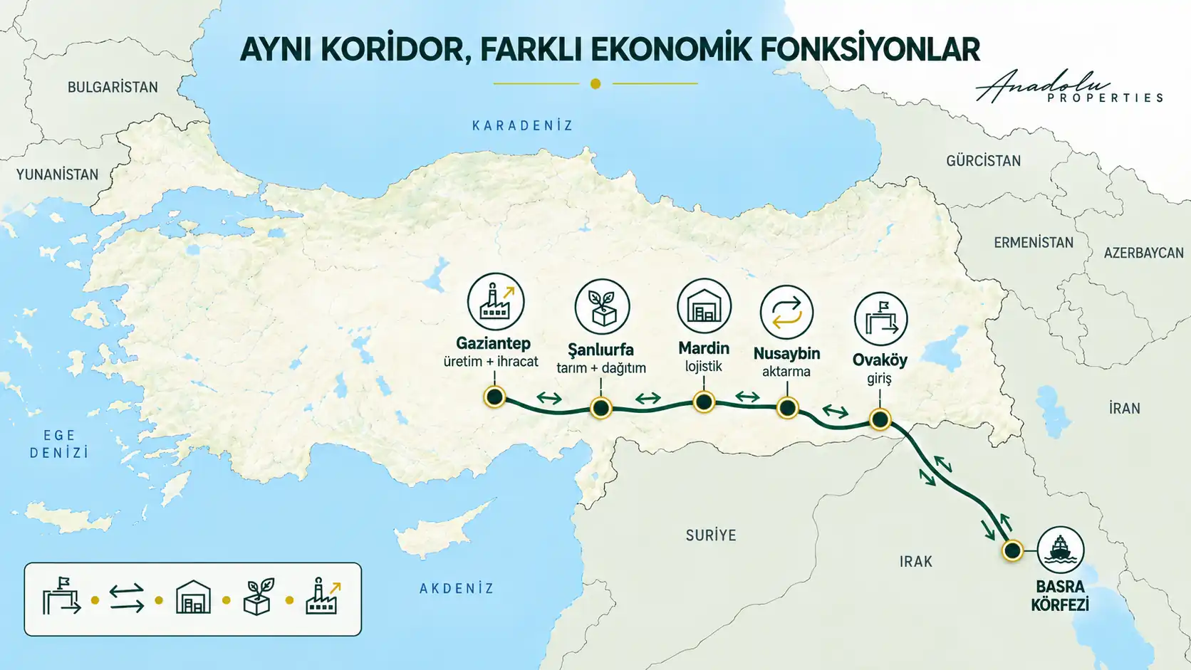
Ovaköy, Nusaybin, Mardin, Şanlıurfa and Gaziantep may all become parts of the same economic corridor, but their functions within the Development Road should not be expected to be identical. To understand the corridor’s real potential, it is more useful to look beyond city names and examine the role each point could assume within the system.
Ovaköy: Is Being a Border Gate Enough to Create an Economic Node?
Ovaköy stands out as the Development Road’s entry point into Türkiye. Naturally, initial attention focuses on the border gate; yet the existence of a border gate alone does not create an economic cluster. What matters is how quickly, continuously and cost-effectively the freight entering at the border can be transferred into Türkiye’s interior.
The planned new motorway of approximately 320 kilometers between Şanlıurfa and Ovaköy, together with the Ovaköy–Nusaybin railway connection, is critical in this respect. Once these links are completed and integrated with existing networks, Ovaköy could become not only a border crossing but one of the points through which international freight enters Türkiye’s transport system.
For real-estate investment analysis, however, “proximity to the border gate” is not sufficient on its own. The micro-locations where customs, freight transfer, storage, heavy-vehicle access and logistics services actually concentrate will be more decisive.
Nusaybin: Railway Integration and Logistics Transit Potential
One of the less-discussed points along this route is Nusaybin. What makes Nusaybin important is not only its proximity to the border, but also the potential for the planned new connection toward Ovaköy to integrate with Türkiye’s existing southeastern railway system.
According to the Ministry of Transport and Infrastructure’s statement dated 13 April 2026, rehabilitation of the 325-kilometer Karkamış–Nusaybin and 25-kilometer Şenyurt–Mardin railway lines was completed, and the combined 350-kilometer network was reopened to train traffic as of 31 March 2026. The Ministry states that this infrastructure will support the planned Ovaköy–Nusaybin railway connection to be built within the scope of the Development Road.
As this connection advances, Nusaybin’s economic function could expand beyond that of a district focused on border trade. The scale at which freight transfer, customs clearance, storage, distribution, maintenance and logistics services develop may determine the district’s future role.
The point where the railway lines connect does not have to be the same point where economic activity clusters.
For this reason, Nusaybin should be assessed not merely through proximity to the station or railway, but by reading heavy-vehicle access, main-road connections, customs functions, industrial and storage areas, planning decisions and the direction of private-sector logistics investment together.
Mardin: Could a New Logistics Economy Emerge Behind Tourism?
When Mardin is mentioned, history, culture and tourism usually come to mind first. Yet the city’s economic geography is broader than these sectors. The reactivation of the Şenyurt–Mardin line and the strengthening of the railway system toward Nusaybin could make Mardin a more visible part of regional freight flows.
Here, the focus should be less on real-estate movement in the city center and more on Mardin’s industrial and logistics hinterland. The possible impact of the Development Road may emerge not in the historic center, but in peripheral areas where transport infrastructure intersects with industry, storage, border trade and distribution functions.
Still, the presence of the physical line is not enough. Actual freight volumes must materialize, the private sector must invest, logistics facilities must become operational and demand must be visible on the ground. The key indicator for Mardin is therefore not the news that “the line passes here,” but whether freight actually interacts with economic functions around the city.
Şanlıurfa: The Intersection of Agriculture, Food Industry and International Logistics
Şanlıurfa may become one of the corridor’s most notable areas of transformation. Until now, the city’s place in Türkiye’s economy has been defined largely by agriculture, the Southeastern Anatolia Project (GAP) and food production. The Development Road has the potential to add a new function to this identity: international logistics transit and distribution.
The planned approximately 320-kilometer motorway between Şanlıurfa and Ovaköy is one of the important infrastructure components of this transformation. Linking the Gaziantep–Şanlıurfa–Mardin–Nusaybin–Ovaköy railway corridor with the Development Road also strengthens the possibility that Şanlıurfa could move beyond being a city along the route and become an intermediate node where production and logistics intersect.
What differentiates Şanlıurfa is the possibility that several economic systems could intersect in the same geography: the agricultural production and food economy created by GAP, Gaziantep’s industrial and export capacity to the west, and the international freight flows planned to arrive from Iraq to the east and southeast.
In the coming years, the micro-locations where new logistics centers, storage investments, cold-chain facilities, food-processing and packaging units, OIZ expansions and distribution activities begin to concentrate will provide important early signals. From a real-estate perspective, the potential should not be sought along the roadside, but where these functions begin to cluster in the same area.
Gaziantep: The Corridor’s Established Production and Export Power
Gaziantep occupies a different position from the other points on this corridor. We are not waiting for a new production economy to emerge here; production already exists. As one of Türkiye’s strongest industrial and export centers, the Development Road’s principal effect on Gaziantep may be to diversify the geography through which existing production accesses external markets rather than to create new industry.
Gaziantep’s industry currently operates through strong connections to ports such as Mersin and İskenderun. To the extent that the Development Road is realized, it could provide an alternative trade and logistics connection toward Iraq and Gulf markets to the southeast.
The critical issue here is two-way movement. While freight may enter Türkiye through Ovaköy, Gaziantep’s production may also move south along the same corridor. If this two-way trade reaches sufficient volume, the corridor could become more than a transit route and evolve into an economic system where production, logistics and international trade converge.
The Difference Between Transit Freight and Economic Freight
This is where the Development Road’s most critical real-estate issue emerges. If a truck or freight train enters Türkiye through Ovaköy and continues west without interacting economically with the cities along the corridor, its regional impact may remain limited.
By contrast, if freight is transferred in Nusaybin, stored in Mardin, processed in Şanlıurfa, connected with production in Gaziantep or distributed from these cities to other parts of Türkiye, a different economic chain emerges. Demand for warehouses, bonded warehouses, logistics facilities, industrial land, commercial service areas and, in some places, housing for employees becomes meaningful only at this second stage.
Transit freight uses the road; economic freight uses the region.
Therefore, when evaluating an international transport corridor, it is necessary to look not only at how many million tons of freight may be carried, but also at what that freight does in the geography it crosses. This is the core distinction we seek in the Türkiye’s New Corridors series.
Planned Projects and Completed Infrastructure Must Not Be Confused
The Development Road is not today a fully completed and operational system across its entire route. While work continues on Al-Faw Port and related transport infrastructure on the Iraqi side, some existing lines in Türkiye have been rehabilitated, but implementation of new motorway and railway links is progressing at different stages depending on the section.
Statements published in August 2026 by the Ministry of Transport and Infrastructure’s international-relations unit show that the financing mechanism for the Development Road, identification of the first sections to be implemented, technical standards, tender and implementation processes, and the Ovaköy connection remain on the Türkiye–Iraq agenda. This clearly indicates that the project is advancing, but that all sections should not be priced as if they were already completed infrastructure.
This distinction is extremely important for real-estate investors. One of the fundamental mistakes made with major infrastructure projects is to treat a project decision as though the infrastructure were already completed and generating economic demand. In reality, implementation schedules can change, financing models can be delayed, phases can diverge, and the locations of logistics centers or freight terminals can become clearer only over time.
The real question is not “where should land be bought?” but where planning, financing, physical infrastructure and genuine private-sector demand begin to advance at the same time.
Accordingly, zoning status, ownership structure, expropriation decisions, OIZ and industrial expansions, official project phases, logistics-center plans, customs infrastructure and actual freight demand should be evaluated together along this corridor. Infrastructure news alone is not an investment rationale.
Anadolu Properties View: Reading the Corridor Through Economic Functions, Not City Names
At Anadolu Properties, when we examine the Development Road, we go beyond seeing a new line beginning at Ovaköy and extending toward western Türkiye. What matters to us is which existing economic systems this route will connect with after entering Türkiye.
For this reason, we do not treat the Gaziantep–Şanlıurfa–Mardin–Nusaybin–Ovaköy route as a corridor with a single character. Ovaköy may serve as the international entry point, while Nusaybin may become one of the transition points where the new connection integrates with the existing railway system. Mardin may acquire a new intermediary role between border trade, industry and logistics. Şanlıurfa could connect its strong agricultural production and food economy with the international transport system. Gaziantep represents the corridor’s already-established production and export strength.
Within the current picture, we believe Nusaybin and Şanlıurfa deserve particularly close monitoring. In Nusaybin, the decisive issue will be how the new connection from Ovaköy integrates with the rehabilitated existing lines and where customs clearance, freight transfer, logistics and storage functions actually develop.
In Şanlıurfa, the key is to track the micro-geographies where new motorway and railway investments begin to intersect with agricultural production, the food industry, organized industrial zones and distribution infrastructure. Here, investment analysis should move beyond the broad city scale and focus on sub-areas where functions converge.
Gaziantep may also become one of the main indicators through which the corridor’s real economic performance can be measured. Whether Gaziantep industry actually begins using the route, whether freight volumes emerge and whether businesses develop new logistics preferences will show the extent to which the project is translating into economic activity.
Accordingly, the early signal we will monitor is not merely progress in road or railway construction. It will be more meaningful to say that the corridor’s economic impact is beginning to reach the ground when new logistics facilities, customs areas, warehouse and bonded-warehouse investments, OIZ expansions, major private-sector investments, land allocations and freight terminals begin to appear within the same micro-geographies.
What turns a transport line into a genuine economic axis is not asphalt or rail, but the fact that production, trade and logistics begin to use that infrastructure.
Not Where the Road Passes, but Where Freight Turns Into Economic Activity
To the extent that it is realized, the Development Road could give Türkiye a new international transport corridor. Yet the real change for the Southeast may arise not simply from a new road or railway line, but from a reshaping of the economic relationships among the cities.
If Gaziantep’s production and export strength, Şanlıurfa’s agricultural and food economy, Mardin’s border and logistics functions, Nusaybin’s railway transit potential and Ovaköy’s international entry role begin to operate within the same system, points we evaluate separately today could become different nodes of a single production and logistics corridor tomorrow.
Building the road alone will not be enough. Freight must actually use the route, the private sector must invest, logistics infrastructure must develop and existing regional production must integrate with the international trade system. From a real-estate perspective, value creation can be assessed more soundly only as these economic functions become visible on the ground.
Those seeking to read the investment map of the future should therefore track not the roadsides, but where freight stops, is processed, stored, distributed and connected with production. At the same time, zoning, ownership, land-use decisions, infrastructure access and market demand must be verified separately for every micro-location.
The Development Road’s real-estate story will begin not where the road passes, but where freight stops, is processed and meets production.
Mustafa Yılmaz
CEO – Anadolu Properties
Europe – Türkiye Investment Bridge